|
|
|||||||||||||||||
| Point ID: 9267 | Downloads | Plots | Site Data | Code: 15012000 |
|
|
|||||||||||||||||
| Download | |
|---|---|
| Site Descriptor Information | Site Time Series Data |
| Link to all available data | |

|

|
| View: | Statistics | Time Series |
| Units: | m3/s |
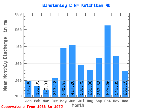
| Statistic | Jan | Feb | Mar | Apr | May | Jun | Jul | Aug | Sep | Oct | Nov | Dec | Annual |
|---|---|---|---|---|---|---|---|---|---|---|---|---|---|
| Mean | 195.88 | 167.46 | 144.96 | 213.16 | 390.64 | 410.17 | 292.69 | 261.90 | 332.61 | 524.99 | 346.86 | 256.13 | 3534.86 |
| Standard Deviation | 153.06 | 121.37 | 80.03 | 84.58 | 89.14 | 85.53 | 92.87 | 122.58 | 125.38 | 171.90 | 132.98 | 143.60 | 476.62 |
| Min | 18.95 | 10.57 | 44.52 | 66.51 | 212.05 | 175.96 | 80.47 | 51.79 | 106.77 | 184.28 | 87.55 | 48.96 | 2647.90 |
| Max | 760.03 | 563.48 | 283.69 | 421.05 | 620.59 | 620.49 | 426.21 | 506.02 | 644.71 | 953.60 | 705.36 | 645.41 | 4405.65 |
| Coefficient of Variation | 0.78 | 0.72 | 0.55 | 0.40 | 0.23 | 0.21 | 0.32 | 0.47 | 0.38 | 0.33 | 0.38 | 0.56 | 0.14 |
| Year | Jan | Feb | Mar | Apr | May | Jun | Jul | Aug | Sep | Oct | Nov | Dec | Annual | 1936 | 165.01 | 379.19 | 558.91 | 557.65 | 249.75 | 1937 | 50.75 | 24.18 | 249.92 | 156.31 | 316.30 | 341.73 | 281.49 | 336.85 | 247.89 | 421.04 | 177.61 | 432.09 | 3014.12 | 1938 | 326.62 | 197.54 | 188.56 | 307.37 | 342.60 | 408.96 | 204.36 | 176.54 | 381.21 | 1947 | 467.59 | 258.14 | 193.26 | 1948 | 338.20 | 62.33 | 84.49 | 83.28 | 448.68 | 360.89 | 207.36 | 178.49 | 644.71 | 509.56 | 323.06 | 122.13 | 3354.87 | 1949 | 157.94 | 47.13 | 171.79 | 350.03 | 499.06 | 505.00 | 336.12 | 326.11 | 386.09 | 643.39 | 422.51 | 130.67 | 3963.29 | 1950 | 25.50 | 39.95 | 80.90 | 121.96 | 375.17 | 443.50 | 290.51 | 317.03 | 315.50 | 222.66 | 197.74 | 226.15 | 2647.90 | 1951 | 148.43 | 44.37 | 105.84 | 202.19 | 470.21 | 467.41 | 205.49 | 154.70 | 121.60 | 387.25 | 193.29 | 241.94 | 2729.91 | 1952 | 60.70 | 129.29 | 104.62 | 261.25 | 370.71 | 415.74 | 318.96 | 268.78 | 457.59 | 463.81 | 298.90 | 164.96 | 3314.95 | 1953 | 71.19 | 172.30 | 257.13 | 168.21 | 514.87 | 287.43 | 326.57 | 127.26 | 458.87 | 646.14 | 365.71 | 324.83 | 3712.03 | 1954 | 111.33 | 563.48 | 52.53 | 86.88 | 403.79 | 407.32 | 312.88 | 135.97 | 232.09 | 507.96 | 469.68 | 474.11 | 3783.62 | 1955 | 227.00 | 191.44 | 96.82 | 240.99 | 318.06 | 503.54 | 402.77 | 494.67 | 328.49 | 662.86 | 287.55 | 48.96 | 3797.63 | 1956 | 18.95 | 81.83 | 45.87 | 255.82 | 620.59 | 318.98 | 158.88 | 445.27 | 245.63 | 492.17 | 453.62 | 433.79 | 3556.70 | 1957 | 106.63 | 69.90 | 57.10 | 203.90 | 446.43 | 403.84 | 303.93 | 165.07 | 154.17 | 283.60 | 485.16 | 206.62 | 2881.94 | 1958 | 386.09 | 135.81 | 136.28 | 287.73 | 395.60 | 175.96 | 80.47 | 451.29 | 237.93 | 629.81 | 374.61 | 351.19 | 3625.56 | 1959 | 137.13 | 157.66 | 283.69 | 203.91 | 362.73 | 453.50 | 403.84 | 245.48 | 381.39 | 576.72 | 565.97 | 645.41 | 4405.65 | 1960 | 149.28 | 169.62 | 272.94 | 421.05 | 485.95 | 400.61 | 426.21 | 243.34 | 331.00 | 741.36 | 351.00 | 359.37 | 4339.00 | 1961 | 318.01 | 258.45 | 131.34 | 358.81 | 277.80 | 372.47 | 160.08 | 201.91 | 413.79 | 900.27 | 420.55 | 145.98 | 3964.26 | 1962 | 760.03 | 283.93 | 61.91 | 241.98 | 275.73 | 441.41 | 251.17 | 200.57 | 310.37 | 381.64 | 364.48 | 460.87 | 4033.22 | 1963 | 373.65 | 317.27 | 84.31 | 111.78 | 212.05 | 343.25 | 240.62 | 66.55 | 326.78 | 500.59 | 270.71 | 333.44 | 3188.65 | 1964 | 299.34 | 311.33 | 139.39 | 238.31 | 301.10 | 620.49 | 425.81 | 335.14 | 277.48 | 630.46 | 284.19 | 183.99 | 4050.59 | 1965 | 262.92 | 292.49 | 176.54 | 141.67 | 281.16 | 323.92 | 167.89 | 51.79 | 106.77 | 583.68 | 196.21 | 207.35 | 2795.40 | 1966 | 137.20 | 126.52 | 268.72 | 235.93 | 418.17 | 382.12 | 264.66 | 329.24 | 393.59 | 413.36 | 303.23 | 218.21 | 3483.30 | 1967 | 207.22 | 187.99 | 107.67 | 66.51 | 483.14 | 428.61 | 370.98 | 432.75 | 613.23 | 669.20 | 349.96 | 181.73 | 4091.03 | 1968 | 301.60 | 145.39 | 253.89 | 202.80 | 320.75 | 355.08 | 231.20 | 102.24 | 476.32 | 463.81 | 446.00 | 104.50 | 3404.73 | 1969 | 24.95 | 10.57 | 44.52 | 311.29 | 394.62 | 305.24 | 271.14 | 506.02 | 191.28 | 184.28 | 705.36 | 397.50 | 3337.10 | 1970 | 117.13 | 365.71 | 220.95 | 195.11 | 361.69 | 475.77 | 299.59 | 369.61 | 335.01 | 440.93 | 165.83 | 60.40 | 3419.85 | 1971 | 219.36 | 197.28 | 85.35 | 187.86 | 307.82 | 436.35 | 233.74 | 229.79 | 374.99 | 354.86 | 361.87 | 121.03 | 3117.84 | 1972 | 74.73 | 51.98 | 272.96 | 134.72 | 473.26 | 532.57 | 397.96 | 341.25 | 292.91 | 600.14 | 323.79 | 130.49 | 3608.59 | 1973 | 211.98 | 136.61 | 148.54 | 214.03 | 417.01 | 460.88 | 392.35 | 264.44 | 436.84 | 457.94 | 87.55 | 145.37 | 3365.28 | 1974 | 55.91 | 181.29 | 67.66 | 235.08 | 464.84 | 460.64 | 425.88 | 232.97 | 193.95 | 953.60 | 343.80 | 387.79 | 3989.20 | 1975 | 196.55 | 70.22 | 96.62 | 168.03 | 359.37 | 471.98 | 387.94 | 222.66 | 264.30 |
|---|
 Return to R-Arctic Net Home Page