|
|
|||||||||||||||||
| Point ID: 9265 | Downloads | Plots | Site Data | Code: 15011880 |
|
|
|||||||||||||||||
| Download | |
|---|---|
| Site Descriptor Information | Site Time Series Data |
| Link to all available data | |

|

|
| View: | Statistics | Time Series |
| Units: | m3/s |
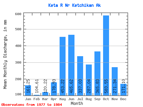
| Statistic | Jan | Feb | Mar | Apr | May | Jun | Jul | Aug | Sep | Oct | Nov | Dec | Annual |
|---|---|---|---|---|---|---|---|---|---|---|---|---|---|
| Mean | 161.22 | 105.50 | 120.21 | 178.93 | 453.16 | 465.62 | 336.99 | 287.01 | 365.84 | 583.46 | 271.33 | 171.07 | 3486.26 |
| Standard Deviation | 115.54 | 58.14 | 65.21 | 63.04 | 89.69 | 137.26 | 105.44 | 116.24 | 197.31 | 215.05 | 153.72 | 164.03 | 452.01 |
| Min | 54.16 | 29.31 | 38.02 | 86.37 | 317.60 | 372.52 | 224.55 | 161.97 | 140.78 | 304.76 | 99.10 | 31.95 | 2991.00 |
| Max | 371.27 | 183.34 | 215.68 | 269.33 | 577.79 | 758.41 | 543.05 | 455.86 | 816.73 | 876.04 | 461.07 | 422.88 | 4136.86 |
| Coefficient of Variation | 0.72 | 0.55 | 0.54 | 0.35 | 0.20 | 0.29 | 0.31 | 0.41 | 0.54 | 0.37 | 0.57 | 0.96 | 0.13 |
| Year | Jan | Feb | Mar | Apr | May | Jun | Jul | Aug | Sep | Oct | Nov | Dec | Annual | 1977 | 161.97 | 140.78 | 712.19 | 164.13 | 61.58 | 1978 | 69.24 | 101.99 | 86.72 | 207.87 | 317.60 | 391.13 | 224.55 | 345.88 | 279.01 | 876.04 | 378.19 | 161.00 | 3428.29 | 1979 | 54.16 | 34.48 | 215.68 | 145.30 | 511.77 | 392.44 | 274.46 | 198.14 | 348.31 | 411.22 | 200.26 | 422.88 | 3190.30 | 1980 | 140.34 | 119.75 | 90.44 | 269.33 | 496.75 | 416.24 | 363.05 | 282.86 | 333.18 | 795.86 | 461.07 | 382.73 | 4136.86 | 1981 | 371.27 | 161.66 | 123.56 | 148.34 | 470.25 | 412.79 | 340.27 | 239.45 | 816.73 | 304.76 | 451.09 | 88.84 | 3933.66 | 1982 | 88.79 | 29.31 | 38.02 | 86.37 | 436.78 | 758.41 | 357.64 | 171.63 | 338.05 | 547.55 | 99.10 | 48.56 | 2991.00 | 1983 | 143.31 | 108.00 | 86.33 | 239.49 | 577.79 | 372.52 | 255.87 | 455.86 | 394.58 | 436.61 | 145.50 | 31.95 | 3237.48 | 1984 | 261.45 | 183.34 | 200.71 | 155.82 | 361.15 | 515.79 | 543.05 | 440.27 | 276.06 |
|---|
 Return to R-Arctic Net Home Page