|
|
|||||||||||||||||
| Point ID: 9257 | Downloads | Plots | Site Data | Code: 15053200 |
|
|
|||||||||||||||||
| Download | |
|---|---|
| Site Descriptor Information | Site Time Series Data |
| Link to all available data | |
|
|
| View: | Statistics | Time Series |
| Units: | m3/s |
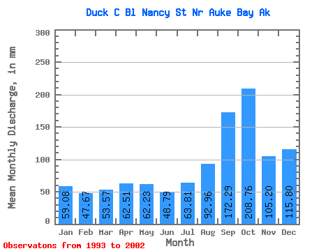
| Statistic | Jan | Feb | Mar | Apr | May | Jun | Jul | Aug | Sep | Oct | Nov | Dec | Annual |
|---|---|---|---|---|---|---|---|---|---|---|---|---|---|
| Mean | 58.77 | 48.19 | 53.93 | 62.23 | 62.34 | 48.77 | 63.62 | 92.81 | 172.22 | 208.40 | 104.87 | 116.03 | 1080.23 |
| Standard Deviation | 32.35 | 24.71 | 29.88 | 34.91 | 28.65 | 15.59 | 19.96 | 42.73 | 71.83 | 95.14 | 55.55 | 74.26 | 313.62 |
| Min | 19.03 | 15.89 | 21.11 | 26.35 | 19.03 | 26.02 | 38.59 | 29.19 | 82.16 | 117.97 | 50.90 | 43.52 | 695.48 |
| Max | 108.19 | 80.61 | 113.24 | 132.95 | 110.93 | 74.81 | 94.52 | 171.07 | 312.54 | 403.61 | 221.44 | 273.03 | 1685.58 |
| Coefficient of Variation | 0.55 | 0.51 | 0.55 | 0.56 | 0.46 | 0.32 | 0.31 | 0.46 | 0.42 | 0.46 | 0.53 | 0.64 | 0.29 |
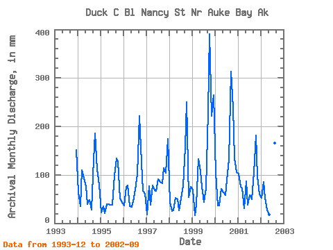
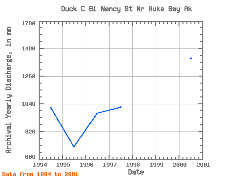
| Year | Jan | Feb | Mar | Apr | May | Jun | Jul | Aug | Sep | Oct | Nov | Dec | Annual | 1993 | 155.93 | 1994 | 65.81 | 32.68 | 113.24 | 92.02 | 78.38 | 39.59 | 49.62 | 29.19 | 131.81 | 191.30 | 111.33 | 82.22 | 1014.25 | 1995 | 23.17 | 33.52 | 21.11 | 39.64 | 41.01 | 38.40 | 38.59 | 101.45 | 133.87 | 130.62 | 50.90 | 43.52 | 695.48 | 1996 | 37.96 | 70.23 | 79.98 | 36.19 | 35.72 | 45.51 | 72.46 | 104.43 | 221.62 | 129.99 | 66.25 | 62.35 | 964.30 | 1997 | 19.03 | 72.05 | 39.20 | 77.53 | 71.07 | 66.71 | 94.52 | 87.71 | 82.16 | 117.97 | 104.31 | 179.79 | 1011.25 | 1998 | 43.19 | 23.89 | 27.01 | 52.40 | 50.99 | 26.02 | 51.98 | 79.53 | 156.05 | 259.19 | 53.64 | 76.99 | 896.79 | 1999 | 72.18 | 15.89 | 38.67 | 132.95 | 110.93 | 74.81 | 45.68 | 74.60 | 229.37 | 403.61 | 221.44 | 273.03 | 1685.58 | 2000 | 108.19 | 34.30 | 37.66 | 71.74 | 65.20 | 58.22 | 92.94 | 136.62 | 312.54 | 247.65 | 134.43 | 108.72 | 1405.01 | 2001 | 105.22 | 70.51 | 74.67 | 31.21 | 88.70 | 37.58 | 60.65 | 50.74 | 106.02 | 186.90 | 96.67 | 61.77 | 969.18 | 2002 | 54.22 | 80.61 | 53.81 | 26.35 | 19.03 | 52.04 | 66.16 | 171.07 | 176.56 |
|---|
 Return to R-Arctic Net Home Page