|
|
|||||||||||||||||
| Point ID: 9253 | Downloads | Plots | Site Data | Code: 15052475 |
|
|
|||||||||||||||||
| Download | |
|---|---|
| Site Descriptor Information | Site Time Series Data |
| Link to all available data | |
|
|
| View: | Statistics | Time Series |
| Units: | m3/s |
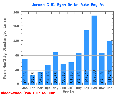
| Statistic | Jan | Feb | Mar | Apr | May | Jun | Jul | Aug | Sep | Oct | Nov | Dec | Annual |
|---|---|---|---|---|---|---|---|---|---|---|---|---|---|
| Mean | 69.41 | 27.41 | 34.54 | 54.08 | 88.16 | 56.14 | 61.15 | 87.12 | 148.34 | 188.00 | 87.62 | 118.72 | 1027.86 |
| Standard Deviation | 35.91 | 22.42 | 13.12 | 48.96 | 39.56 | 31.19 | 20.96 | 49.96 | 53.37 | 56.51 | 27.71 | 96.23 | 329.21 |
| Min | 39.78 | 4.84 | 18.41 | 7.87 | 42.01 | 17.81 | 36.77 | 20.20 | 84.09 | 125.61 | 46.08 | 30.26 | 786.18 |
| Max | 128.24 | 54.21 | 53.64 | 132.12 | 155.15 | 111.30 | 96.33 | 169.83 | 205.26 | 251.48 | 122.75 | 235.86 | 1494.53 |
| Coefficient of Variation | 0.52 | 0.82 | 0.38 | 0.91 | 0.45 | 0.56 | 0.34 | 0.57 | 0.36 | 0.30 | 0.32 | 0.81 | 0.32 |
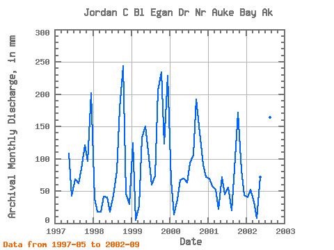
| Year | Jan | Feb | Mar | Apr | May | Jun | Jul | Aug | Sep | Oct | Nov | Dec | Annual | 1997 | 111.62 | 42.62 | 70.35 | 63.73 | 84.09 | 125.61 | 96.10 | 208.44 | 1998 | 39.78 | 16.23 | 18.41 | 41.60 | 42.01 | 17.81 | 44.77 | 83.38 | 178.42 | 251.48 | 46.08 | 30.26 | 806.65 | 1999 | 128.24 | 4.84 | 27.95 | 132.12 | 155.15 | 111.30 | 61.15 | 76.38 | 205.26 | 241.35 | 122.75 | 235.86 | 1494.53 | 2000 | 66.70 | 13.06 | 38.93 | 66.97 | 71.97 | 62.94 | 96.33 | 109.16 | 192.26 | 144.61 | 90.86 | 74.19 | 1024.07 | 2001 | 71.38 | 54.21 | 53.64 | 21.83 | 74.53 | 45.06 | 57.56 | 20.20 | 84.88 | 176.97 | 82.30 | 44.83 | 786.18 | 2002 | 40.98 | 48.68 | 33.78 | 7.87 | 73.69 | 57.11 | 36.77 | 169.83 | 145.11 |
|---|
 Return to R-Arctic Net Home Page