|
|
|||||||||||||||||
| Point ID: 9252 | Downloads | Plots | Site Data | Code: 15052009 |
|
|
|||||||||||||||||
| Download | |
|---|---|
| Site Descriptor Information | Site Time Series Data |
| Link to all available data | |
|
|
| View: | Statistics | Time Series |
| Units: | m3/s |
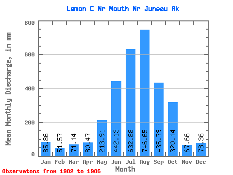
| Statistic | Jan | Feb | Mar | Apr | May | Jun | Jul | Aug | Sep | Oct | Nov | Dec | Annual |
|---|---|---|---|---|---|---|---|---|---|---|---|---|---|
| Mean | 85.85 | 52.02 | 71.14 | 80.47 | 213.89 | 442.12 | 632.77 | 746.54 | 435.77 | 320.10 | 67.66 | 78.34 | 3145.42 |
| Standard Deviation | 48.27 | 18.08 | 46.00 | 30.95 | 63.28 | 64.07 | 156.08 | 143.52 | 110.54 | 104.72 | 4.26 | 81.21 | 273.65 |
| Min | 46.62 | 28.22 | 29.58 | 54.34 | 175.03 | 351.93 | 408.07 | 608.05 | 316.45 | 216.81 | 64.37 | 32.05 | 2867.36 |
| Max | 152.22 | 68.41 | 128.04 | 124.06 | 307.77 | 499.14 | 767.45 | 923.66 | 548.73 | 464.70 | 73.64 | 199.87 | 3414.44 |
| Coefficient of Variation | 0.56 | 0.35 | 0.65 | 0.39 | 0.30 | 0.14 | 0.25 | 0.19 | 0.25 | 0.33 | 0.06 | 1.04 | 0.09 |
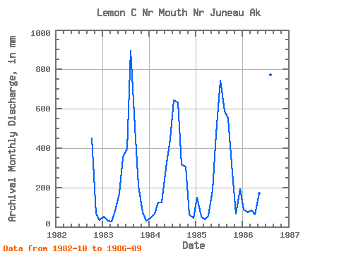
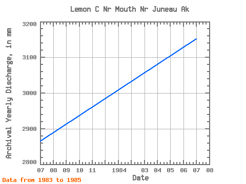
| Year | Jan | Feb | Mar | Apr | May | Jun | Jul | Aug | Sep | Oct | Nov | Dec | Annual | 1982 | 464.70 | 67.78 | 35.97 | 1983 | 53.88 | 28.22 | 29.58 | 80.08 | 177.01 | 351.93 | 408.07 | 923.66 | 508.38 | 216.81 | 73.64 | 32.05 | 2867.36 | 1984 | 46.62 | 63.40 | 128.04 | 124.06 | 307.77 | 444.93 | 663.67 | 654.79 | 316.45 | 314.75 | 64.37 | 45.46 | 3154.45 | 1985 | 152.22 | 48.06 | 38.32 | 54.34 | 195.74 | 472.48 | 767.45 | 608.05 | 548.73 | 284.14 | 64.86 | 199.87 | 3414.44 | 1986 | 90.67 | 68.41 | 88.61 | 63.41 | 175.03 | 499.14 | 691.90 | 799.66 | 369.54 |
|---|
 Return to R-Arctic Net Home Page