|
|
|||||||||||||||||
| Point ID: 9249 | Downloads | Plots | Site Data | Code: 15031000 |
|
|
|||||||||||||||||
| Download | |
|---|---|
| Site Descriptor Information | Site Time Series Data |
| Link to all available data | |
|

|
| View: | Statistics | Time Series |
| Units: | m3/s |
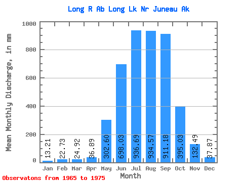
| Statistic | Jan | Feb | Mar | Apr | May | Jun | Jul | Aug | Sep | Oct | Nov | Dec | Annual |
|---|---|---|---|---|---|---|---|---|---|---|---|---|---|
| Mean | 13.22 | 22.98 | 24.94 | 36.95 | 302.53 | 698.06 | 936.50 | 934.45 | 911.15 | 395.02 | 132.46 | 37.86 | 4364.68 |
| Standard Deviation | 7.94 | 39.29 | 39.15 | 19.21 | 81.47 | 219.03 | 248.30 | 180.86 | 561.59 | 237.31 | 90.65 | 24.19 | 965.37 |
| Min | 3.56 | 1.37 | 0.00 | 7.51 | 162.57 | 373.92 | 574.21 | 645.67 | 396.35 | 195.81 | 29.82 | 15.69 | 2692.66 |
| Max | 27.70 | 131.21 | 132.30 | 82.84 | 441.11 | 1059.20 | 1334.14 | 1224.24 | 2353.49 | 939.92 | 326.94 | 81.69 | 6462.12 |
| Coefficient of Variation | 0.60 | 1.71 | 1.57 | 0.52 | 0.27 | 0.31 | 0.27 | 0.19 | 0.62 | 0.60 | 0.68 | 0.64 | 0.22 |
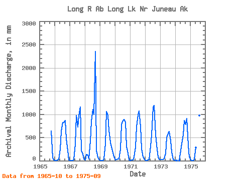
| Year | Jan | Feb | Mar | Apr | May | Jun | Jul | Aug | Sep | Oct | Nov | Dec | Annual | 1965 | 660.60 | 57.53 | 21.55 | 1966 | 8.58 | 6.64 | 15.03 | 31.41 | 259.88 | 628.26 | 846.87 | 845.59 | 862.56 | 479.35 | 218.60 | 21.18 | 4205.56 | 1967 | 11.05 | 6.89 | 5.24 | 26.07 | 373.64 | 975.55 | 755.20 | 993.28 | 1153.87 | 223.00 | 147.70 | 43.85 | 4706.49 | 1968 | 19.11 | 131.21 | 132.30 | 35.42 | 441.11 | 839.79 | 1142.32 | 1028.88 | 2353.49 | 232.90 | 72.09 | 29.11 | 6462.12 | 1969 | 3.56 | 1.37 | 2.58 | 42.10 | 373.20 | 1059.20 | 1005.68 | 672.08 | 396.35 | 304.47 | 168.15 | 81.69 | 4091.16 | 1970 | 19.66 | 29.60 | 34.53 | 41.54 | 255.77 | 778.01 | 893.58 | 920.24 | 823.65 | 311.75 | 156.01 | 16.81 | 4265.89 | 1971 | 7.44 | 11.12 | 14.07 | 82.84 | 301.75 | 735.68 | 1013.40 | 1108.87 | 729.77 | 256.70 | 75.66 | 36.13 | 4349.03 | 1972 | 10.53 | 7.29 | 16.82 | 27.37 | 333.25 | 550.31 | 1188.78 | 1224.24 | 551.92 | 345.66 | 72.14 | 33.14 | 4323.12 | 1973 | 27.70 | 27.59 | 23.41 | 43.00 | 162.57 | 495.12 | 610.83 | 645.67 | 428.78 | 195.81 | 29.82 | 15.69 | 2692.66 | 1974 | 4.55 | 1.37 | 0.00 | 7.51 | 225.50 | 373.92 | 574.21 | 895.32 | 784.16 | 939.92 | 326.94 | 79.41 | 4186.07 | 1975 | 20.01 | 6.70 | 5.43 | 32.20 | 298.67 | 544.74 | 1334.14 | 1010.36 | 1026.99 |
|---|
 Return to R-Arctic Net Home Page