|
|
|||||||||||||||||
| Point ID: 9245 | Downloads | Plots | Site Data | Code: 15046000 |
|
|
|||||||||||||||||
| Download | |
|---|---|
| Site Descriptor Information | Site Time Series Data |
| Link to all available data | |
|
|
| View: | Statistics | Time Series |
| Units: | m3/s |
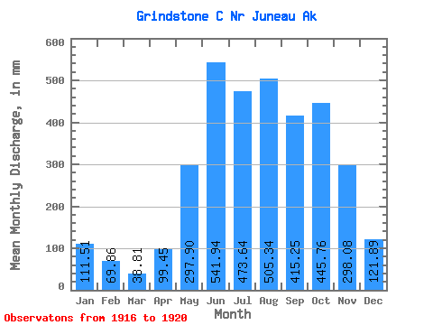
| Statistic | Jan | Feb | Mar | Apr | May | Jun | Jul | Aug | Sep | Oct | Nov | Dec | Annual |
|---|---|---|---|---|---|---|---|---|---|---|---|---|---|
| Mean | 111.39 | 70.56 | 38.73 | 99.56 | 297.94 | 541.89 | 473.50 | 505.35 | 415.33 | 445.60 | 298.13 | 121.88 | 3354.78 |
| Standard Deviation | 33.84 | 28.70 | 14.50 | 38.64 | 50.34 | 91.00 | 169.17 | 146.80 | 128.35 | 150.46 | 183.94 | 47.11 | 647.38 |
| Min | 73.53 | 43.99 | 23.62 | 53.82 | 246.36 | 408.65 | 283.38 | 377.42 | 235.45 | 206.71 | 167.27 | 59.83 | 2729.40 |
| Max | 149.23 | 103.72 | 54.37 | 144.35 | 379.44 | 613.40 | 672.23 | 701.71 | 510.05 | 615.54 | 616.63 | 192.24 | 4263.52 |
| Coefficient of Variation | 0.30 | 0.41 | 0.37 | 0.39 | 0.17 | 0.17 | 0.36 | 0.29 | 0.31 | 0.34 | 0.62 | 0.39 | 0.19 |
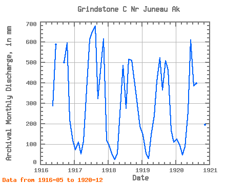
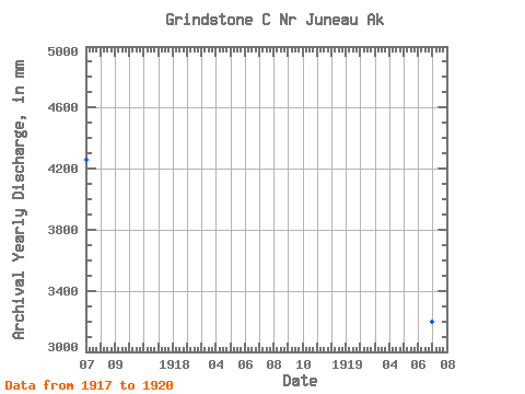
| Year | Jan | Feb | Mar | Apr | May | Jun | Jul | Aug | Sep | Oct | Nov | Dec | Annual | 1916 | 297.29 | 589.67 | 499.80 | 615.54 | 219.43 | 120.10 | 1917 | 73.53 | 103.72 | 54.37 | 113.83 | 379.44 | 613.40 | 672.23 | 701.71 | 322.33 | 500.99 | 616.63 | 123.77 | 4263.52 | 1918 | 94.54 | 43.99 | 23.62 | 53.82 | 297.53 | 486.10 | 283.38 | 531.92 | 510.05 | 425.47 | 291.86 | 192.24 | 3224.44 | 1919 | 149.23 | 49.33 | 29.60 | 144.35 | 246.36 | 408.65 | 540.52 | 377.42 | 509.05 | 479.25 | 167.27 | 113.43 | 3201.76 | 1920 | 128.28 | 85.20 | 47.34 | 86.23 | 269.10 | 611.61 | 397.87 | 410.35 | 235.45 | 206.71 | 195.46 | 59.83 | 2729.40 |
|---|
 Return to R-Arctic Net Home Page