|
|
|||||||||||||||||
| Point ID: 9238 | Downloads | Plots | Site Data | Code: 15081497 |
|
|
|||||||||||||||||
| Download | |
|---|---|
| Site Descriptor Information | Site Time Series Data |
| Link to all available data | |

|

|
| View: | Statistics | Time Series |
| Units: | m3/s |
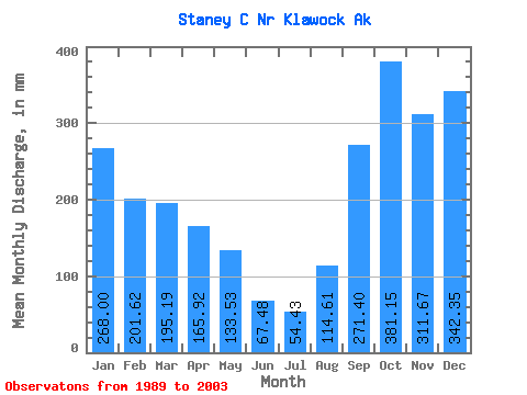
| Statistic | Jan | Feb | Mar | Apr | May | Jun | Jul | Aug | Sep | Oct | Nov | Dec | Annual |
|---|---|---|---|---|---|---|---|---|---|---|---|---|---|
| Mean | 267.96 | 203.36 | 195.16 | 165.92 | 133.50 | 67.47 | 54.42 | 114.61 | 271.40 | 381.09 | 311.68 | 342.30 | 2492.57 |
| Standard Deviation | 96.50 | 139.78 | 77.03 | 65.62 | 75.38 | 31.91 | 29.69 | 79.76 | 114.82 | 115.63 | 133.56 | 175.07 | 555.18 |
| Min | 138.69 | 80.05 | 60.14 | 80.60 | 45.70 | 14.82 | 12.79 | 15.40 | 93.22 | 233.03 | 112.62 | 154.27 | 1697.00 |
| Max | 452.60 | 518.21 | 326.87 | 313.05 | 322.88 | 140.97 | 115.90 | 271.47 | 503.03 | 649.54 | 557.80 | 734.61 | 3628.45 |
| Coefficient of Variation | 0.36 | 0.69 | 0.40 | 0.40 | 0.56 | 0.47 | 0.55 | 0.70 | 0.42 | 0.30 | 0.43 | 0.51 | 0.22 |
| Year | Jan | Feb | Mar | Apr | May | Jun | Jul | Aug | Sep | Oct | Nov | Dec | Annual | 1989 | 216.50 | 355.19 | 494.67 | 474.86 | 1990 | 284.89 | 158.09 | 289.76 | 197.16 | 89.19 | 28.83 | 29.68 | 49.63 | 186.13 | 460.45 | 294.93 | 614.78 | 2673.63 | 1991 | 266.94 | 518.21 | 118.56 | 204.29 | 184.48 | 87.69 | 72.37 | 191.87 | 229.80 | 441.66 | 557.80 | 734.61 | 3628.45 | 1992 | 452.60 | 224.90 | 151.46 | 184.10 | 212.94 | 67.07 | 43.27 | 45.12 | 337.20 | 260.50 | 315.81 | 257.65 | 2557.86 | 1993 | 285.65 | 506.87 | 261.26 | 96.80 | 91.97 | 14.82 | 12.79 | 15.40 | 98.99 | 522.43 | 467.52 | 399.31 | 2794.73 | 1994 | 276.96 | 80.05 | 326.87 | 169.47 | 126.73 | 98.07 | 80.11 | 37.88 | 438.24 | 389.98 | 332.83 | 249.36 | 2601.34 | 1995 | 148.45 | 134.28 | 155.47 | 167.79 | 65.40 | 50.48 | 40.53 | 103.65 | 93.22 | 405.72 | 264.53 | 197.84 | 1826.23 | 1996 | 153.28 | 162.51 | 233.80 | 142.07 | 53.98 | 69.61 | 27.37 | 104.51 | 223.68 | 256.23 | 112.62 | 154.27 | 1697.00 | 1997 | 219.81 | 255.89 | 220.18 | 313.05 | 78.31 | 67.74 | 115.90 | 73.37 | 258.52 | 430.82 | 211.94 | 478.29 | 2727.27 | 1998 | 138.69 | 171.41 | 117.91 | 109.28 | 45.70 | 27.75 | 32.77 | 221.93 | 192.03 | 307.62 | 122.01 | 234.51 | 1721.87 | 1999 | 331.56 | 129.88 | 131.16 | 268.40 | 322.88 | 140.97 | 59.24 | 144.48 | 260.72 | 649.54 | 418.21 | 304.07 | 3152.34 | 2000 | 249.47 | 98.23 | 272.18 | 151.37 | 143.82 | 80.88 | 103.50 | 207.30 | 329.96 | 292.31 | 310.72 | 219.00 | 2452.53 | 2001 | 412.46 | 137.39 | 216.34 | 137.00 | 184.37 | 80.17 | 60.20 | 80.20 | 360.31 | 329.71 | 216.93 | 171.89 | 2383.20 | 2002 | 180.02 | 182.43 | 60.14 | 101.50 | 156.31 | 64.25 | 47.68 | 271.47 | 342.67 | 233.03 | 242.96 | 301.72 | 2186.99 | 2003 | 350.66 | 86.92 | 177.21 | 80.60 | 112.96 | 66.25 | 36.48 | 57.68 | 503.03 |
|---|
 Return to R-Arctic Net Home Page