|
|
|||||||||||||||||
| Point ID: 9234 | Downloads | Plots | Site Data | Code: 15080500 |
|
|
|||||||||||||||||
| Download | |
|---|---|
| Site Descriptor Information | Site Time Series Data |
| Link to all available data | |

|

|
| View: | Statistics | Time Series |
| Units: | m3/s |
| Statistic | Jan | Feb | Mar | Apr | May | Jun | Jul | Aug | Sep | Oct | Nov | Dec | Annual |
|---|---|---|---|---|---|---|---|---|---|---|---|---|---|
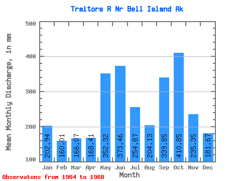
| Mean | 202.94 | 161.38 | 166.04 | 168.40 | 352.27 | 373.47 | 254.85 | 204.12 | 339.83 | 410.77 | 235.35 | 181.66 | 2807.77 |
| Standard Deviation | 91.66 | 33.65 | 118.22 | 53.36 | 96.81 | 85.43 | 87.14 | 84.00 | 206.64 | 81.00 | 34.49 | 27.33 | 452.25 |
| Min | 98.62 | 124.85 | 58.14 | 90.56 | 240.26 | 304.53 | 162.47 | 64.72 | 53.38 | 336.80 | 193.41 | 147.00 | 2286.13 |
| Max | 312.84 | 204.19 | 271.85 | 205.72 | 439.14 | 521.50 | 375.57 | 269.17 | 565.25 | 525.96 | 276.07 | 213.81 | 3089.84 |
| Coefficient of Variation | 0.45 | 0.21 | 0.71 | 0.32 | 0.28 | 0.23 | 0.34 | 0.41 | 0.61 | 0.20 | 0.15 | 0.15 | 0.16 |
| Year | Jan | Feb | Mar | Apr | May | Jun | Jul | Aug | Sep | Oct | Nov | Dec | Annual | 1964 | 521.50 | 375.57 | 266.99 | 213.33 | 525.96 | 276.07 | 181.68 | 1965 | 233.54 | 147.96 | 69.40 | 177.12 | 240.26 | 330.00 | 162.47 | 64.72 | 53.38 | 397.02 | 227.27 | 184.13 | 2286.13 | 1966 | 98.62 | 124.85 | 264.77 | 200.22 | 439.14 | 355.50 | 212.70 | 226.28 | 386.96 | 336.80 | 193.41 | 213.81 | 3047.33 | 1967 | 166.74 | 204.19 | 58.14 | 90.56 | 426.93 | 304.53 | 313.71 | 269.17 | 480.24 | 383.31 | 244.66 | 147.00 | 3089.84 | 1968 | 312.84 | 168.50 | 271.85 | 205.72 | 302.76 | 355.82 | 209.82 | 193.43 | 565.25 |
|---|
 Return to R-Arctic Net Home Page