|
|
|||||||||||||||||
| Point ID: 9230 | Downloads | Plots | Site Data | Code: 15216008 |
|
|
|||||||||||||||||
| Download | |
|---|---|
| Site Descriptor Information | Site Time Series Data |
| Link to all available data | |
|
|
| View: | Statistics | Time Series |
| Units: | m3/s |
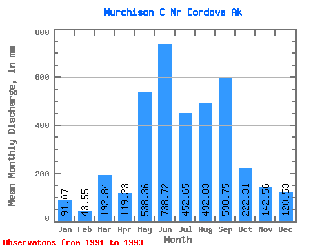
| Statistic | Jan | Feb | Mar | Apr | May | Jun | Jul | Aug | Sep | Oct | Nov | Dec | Annual |
|---|---|---|---|---|---|---|---|---|---|---|---|---|---|
| Mean | 89.93 | 44.03 | 193.64 | 120.31 | 537.85 | 738.81 | 451.24 | 492.23 | 599.75 | 221.80 | 142.13 | 121.16 | 3576.43 |
| Standard Deviation | 113.50 | 4.60 | 262.36 | 1.41 | 211.11 | 287.26 | 384.41 | 95.66 | 752.62 | 66.52 | 12.46 | 135.30 | |
| Min | 9.68 | 40.78 | 8.12 | 119.32 | 388.57 | 535.68 | 179.43 | 424.59 | 67.56 | 174.76 | 133.31 | 25.48 | 3576.43 |
| Max | 170.18 | 47.28 | 379.15 | 121.31 | 687.12 | 941.93 | 723.06 | 559.88 | 1131.93 | 268.84 | 150.94 | 216.83 | 3576.43 |
| Coefficient of Variation | 1.26 | 0.10 | 1.35 | 0.01 | 0.39 | 0.39 | 0.85 | 0.19 | 1.25 | 0.30 | 0.09 | 1.12 |
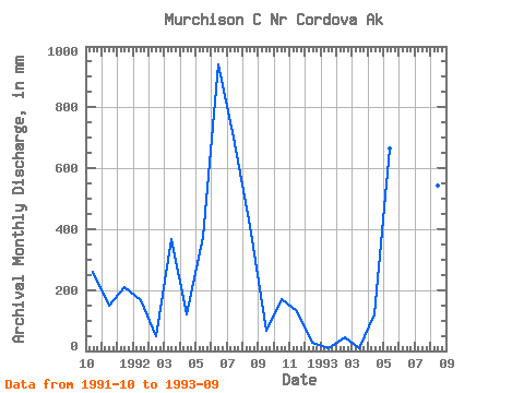
| Year | Jan | Feb | Mar | Apr | May | Jun | Jul | Aug | Sep | Oct | Nov | Dec | Annual | 1991 | 268.84 | 150.94 | 216.83 | 1992 | 170.18 | 47.28 | 379.15 | 119.32 | 388.57 | 941.93 | 723.06 | 424.59 | 67.56 | 174.76 | 133.31 | 25.48 | 3576.43 | 1993 | 9.68 | 40.78 | 8.12 | 121.31 | 687.12 | 535.68 | 179.43 | 559.88 | 1131.93 |
|---|
 Return to R-Arctic Net Home Page