|
|
|||||||||||||||||
| Point ID: 9229 | Downloads | Plots | Site Data | Code: 15216003 |
|
|
|||||||||||||||||
| Download | |
|---|---|
| Site Descriptor Information | Site Time Series Data |
| Link to all available data | |
|
|
| View: | Statistics | Time Series |
| Units: | m3/s |
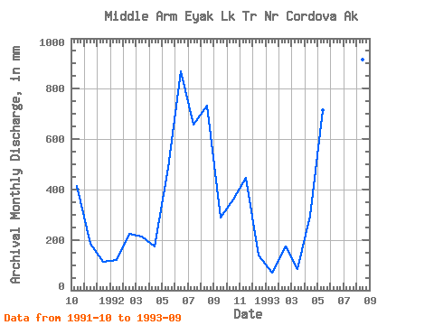
| Statistic | Jan | Feb | Mar | Apr | May | Jun | Jul | Aug | Sep | Oct | Nov | Dec | Annual |
|---|---|---|---|---|---|---|---|---|---|---|---|---|---|
| Mean | 97.30 | 187.33 | 153.70 | 235.76 | 618.58 | 708.02 | 515.07 | 850.80 | 668.89 | 400.70 | 314.94 | 129.83 | 4776.55 |
| Standard Deviation | 36.28 | 31.80 | 95.59 | 85.28 | 167.20 | 227.63 | 232.03 | 134.00 | 535.84 | 40.84 | 185.23 | 17.89 | |
| Min | 71.64 | 164.84 | 86.11 | 175.46 | 500.35 | 547.06 | 351.00 | 756.05 | 289.99 | 371.82 | 183.96 | 117.19 | 4776.55 |
| Max | 122.95 | 209.82 | 221.29 | 296.06 | 736.81 | 868.98 | 679.14 | 945.56 | 1047.78 | 429.57 | 445.92 | 142.48 | 4776.55 |
| Coefficient of Variation | 0.37 | 0.17 | 0.62 | 0.36 | 0.27 | 0.32 | 0.45 | 0.16 | 0.80 | 0.10 | 0.59 | 0.14 |
| Year | Jan | Feb | Mar | Apr | May | Jun | Jul | Aug | Sep | Oct | Nov | Dec | Annual | 1991 | 429.57 | 183.96 | 117.19 | 1992 | 122.95 | 209.82 | 221.29 | 175.46 | 500.35 | 868.98 | 679.14 | 756.05 | 289.99 | 371.82 | 445.92 | 142.48 | 4776.55 | 1993 | 71.64 | 164.84 | 86.11 | 296.06 | 736.81 | 547.06 | 351.00 | 945.56 | 1047.78 |
|---|
 Return to R-Arctic Net Home Page
