|
|
|||||||||||||||||
| Point ID: 9212 | Downloads | Plots | Site Data | Code: 15237700 |
|
|
|||||||||||||||||
| Download | |
|---|---|
| Site Descriptor Information | Site Time Series Data |
| Link to all available data | |
|
|
| View: | Statistics | Time Series |
| Units: | m3/s |
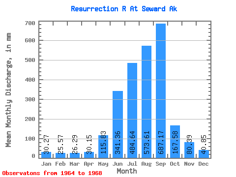
| Statistic | Jan | Feb | Mar | Apr | May | Jun | Jul | Aug | Sep | Oct | Nov | Dec | Annual |
|---|---|---|---|---|---|---|---|---|---|---|---|---|---|
| Mean | 30.27 | 25.79 | 26.29 | 30.16 | 115.81 | 341.36 | 484.56 | 573.52 | 687.17 | 167.56 | 80.39 | 40.84 | 2527.69 |
| Standard Deviation | 15.09 | 16.73 | 13.40 | 18.31 | 39.64 | 36.92 | 74.64 | 159.28 | 279.80 | 44.32 | 41.36 | 20.07 | 320.56 |
| Min | 16.49 | 14.69 | 11.89 | 16.47 | 60.86 | 306.87 | 438.16 | 422.51 | 403.91 | 114.63 | 30.60 | 20.59 | 2228.35 |
| Max | 51.06 | 50.70 | 38.05 | 56.76 | 153.50 | 380.26 | 570.67 | 739.95 | 963.37 | 204.23 | 114.85 | 66.54 | 2865.92 |
| Coefficient of Variation | 0.50 | 0.65 | 0.51 | 0.61 | 0.34 | 0.11 | 0.15 | 0.28 | 0.41 | 0.26 | 0.52 | 0.49 | 0.13 |
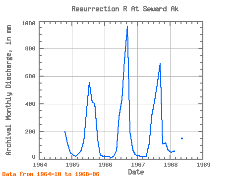
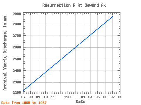
| Year | Jan | Feb | Mar | Apr | May | Jun | Jul | Aug | Sep | Oct | Nov | Dec | Annual | 1964 | 204.09 | 114.03 | 45.94 | 1965 | 31.02 | 19.55 | 38.05 | 56.76 | 132.35 | 365.39 | 570.67 | 422.51 | 403.91 | 147.29 | 30.60 | 20.59 | 2228.35 | 1966 | 16.49 | 14.69 | 11.89 | 16.47 | 60.86 | 306.87 | 444.87 | 739.95 | 963.37 | 204.23 | 62.07 | 30.29 | 2865.92 | 1967 | 22.51 | 18.21 | 17.89 | 20.01 | 116.53 | 312.91 | 438.16 | 558.10 | 694.23 | 114.63 | 114.85 | 66.54 | 2488.79 | 1968 | 51.06 | 50.70 | 37.35 | 27.39 | 153.50 | 380.26 |
|---|
 Return to R-Arctic Net Home Page