|
|
|||||||||||||||||
| Point ID: 9211 | Downloads | Plots | Site Data | Code: 15238982 |
|
|
|||||||||||||||||
| Download | |
|---|---|
| Site Descriptor Information | Site Time Series Data |
| Link to all available data | |
|
|
| View: | Statistics | Time Series |
| Units: | m3/s |
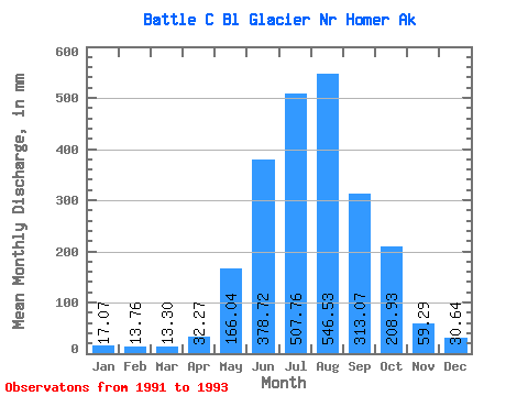
| Statistic | Jan | Feb | Mar | Apr | May | Jun | Jul | Aug | Sep | Oct | Nov | Dec | Annual |
|---|---|---|---|---|---|---|---|---|---|---|---|---|---|
| Mean | 17.05 | 13.89 | 13.34 | 32.31 | 166.06 | 378.70 | 507.68 | 546.48 | 313.04 | 208.88 | 59.28 | 30.66 | 1573.37 |
| Standard Deviation | 1.73 | 5.39 | 5.45 | 23.63 | 77.75 | 23.35 | 98.71 | 166.71 | 211.34 | 225.15 | 38.73 | 24.37 | |
| Min | 15.83 | 10.08 | 9.48 | 15.60 | 111.08 | 362.19 | 394.87 | 367.74 | 86.27 | 72.67 | 31.90 | 13.43 | 1573.37 |
| Max | 18.27 | 17.71 | 17.19 | 49.01 | 221.04 | 395.20 | 578.22 | 697.73 | 504.51 | 468.75 | 86.66 | 47.89 | 1573.37 |
| Coefficient of Variation | 0.10 | 0.39 | 0.41 | 0.73 | 0.47 | 0.06 | 0.19 | 0.30 | 0.68 | 1.08 | 0.65 | 0.80 |
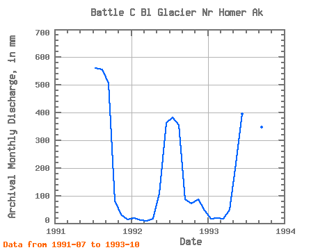
| Year | Jan | Feb | Mar | Apr | May | Jun | Jul | Aug | Sep | Oct | Nov | Dec | Annual | 1991 | 578.22 | 573.98 | 504.51 | 85.21 | 31.90 | 13.43 | 1992 | 18.27 | 10.08 | 9.48 | 15.60 | 111.08 | 362.19 | 394.87 | 367.74 | 86.27 | 72.67 | 86.66 | 47.89 | 1573.37 | 1993 | 15.83 | 17.71 | 17.19 | 49.01 | 221.04 | 395.20 | 549.95 | 697.73 | 348.35 | 468.75 |
|---|
 Return to R-Arctic Net Home Page