|
|
|||||||||||||||||
| Point ID: 9207 | Downloads | Plots | Site Data | Code: 15238795 |
|
|
|||||||||||||||||
| Download | |
|---|---|
| Site Descriptor Information | Site Time Series Data |
| Link to all available data | |
|
|
| View: | Statistics | Time Series |
| Units: | m3/s |
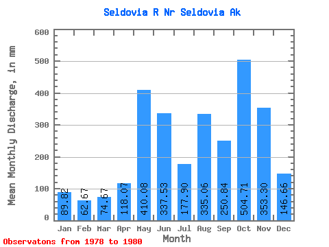
| Statistic | Jan | Feb | Mar | Apr | May | Jun | Jul | Aug | Sep | Oct | Nov | Dec | Annual |
|---|---|---|---|---|---|---|---|---|---|---|---|---|---|
| Mean | 89.80 | 63.22 | 74.66 | 118.08 | 410.02 | 337.55 | 177.88 | 335.01 | 250.85 | 504.66 | 353.31 | 146.65 | 2993.13 |
| Standard Deviation | 7.51 | 2.40 | 8.03 | 46.92 | 236.57 | 68.45 | |||||||
| Min | 84.49 | 61.53 | 68.98 | 118.08 | 410.02 | 337.55 | 177.88 | 335.01 | 250.85 | 471.48 | 186.03 | 98.24 | 2993.13 |
| Max | 95.12 | 64.92 | 80.34 | 118.08 | 410.02 | 337.55 | 177.88 | 335.01 | 250.85 | 537.84 | 520.59 | 195.05 | 2993.13 |
| Coefficient of Variation | 0.08 | 0.04 | 0.11 | 0.09 | 0.67 | 0.47 |
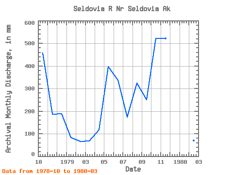
| Year | Jan | Feb | Mar | Apr | May | Jun | Jul | Aug | Sep | Oct | Nov | Dec | Annual | 1978 | 471.48 | 186.03 | 195.05 | 1979 | 84.49 | 61.53 | 68.98 | 118.08 | 410.02 | 337.55 | 177.88 | 335.01 | 250.85 | 537.84 | 520.59 | 98.24 | 2993.13 | 1980 | 95.12 | 64.92 | 80.34 |
|---|
 Return to R-Arctic Net Home Page