|
|
|||||||||||||||||
| Point ID: 9197 | Downloads | Plots | Site Data | Code: 15237020 |
|
|
|||||||||||||||||
| Download | |
|---|---|
| Site Descriptor Information | Site Time Series Data |
| Link to all available data | |
|
|
| View: | Statistics | Time Series |
| Units: | m3/s |
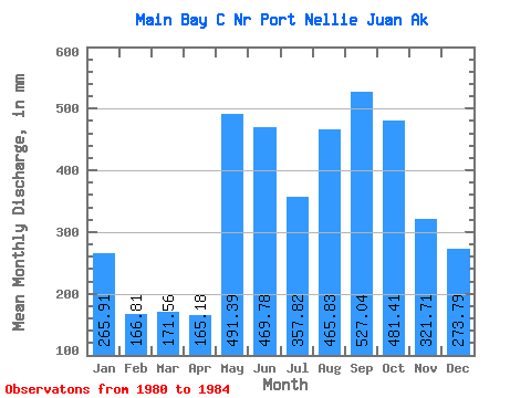
| Statistic | Jan | Feb | Mar | Apr | May | Jun | Jul | Aug | Sep | Oct | Nov | Dec | Annual |
|---|---|---|---|---|---|---|---|---|---|---|---|---|---|
| Mean | 265.82 | 168.20 | 171.57 | 165.11 | 491.32 | 469.80 | 357.68 | 465.82 | 526.97 | 481.27 | 321.71 | 273.77 | 4318.25 |
| Standard Deviation | 184.42 | 115.48 | 117.98 | 15.55 | 133.39 | 229.15 | 107.05 | 346.22 | 244.00 | 284.68 | 117.82 | 144.06 | 1167.29 |
| Min | 48.85 | 32.84 | 62.45 | 143.49 | 376.35 | 323.17 | 255.20 | 197.97 | 197.40 | 218.52 | 160.42 | 123.89 | 3484.23 |
| Max | 499.63 | 290.15 | 285.11 | 179.58 | 626.92 | 809.93 | 493.94 | 974.00 | 730.45 | 822.59 | 424.71 | 431.20 | 5652.24 |
| Coefficient of Variation | 0.69 | 0.69 | 0.69 | 0.09 | 0.27 | 0.49 | 0.30 | 0.74 | 0.46 | 0.59 | 0.37 | 0.53 | 0.27 |
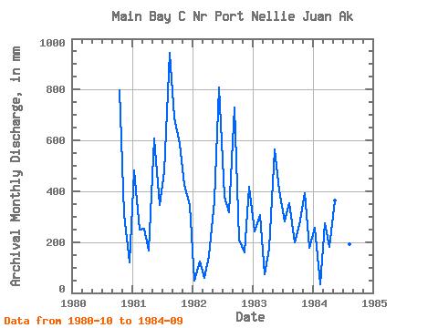
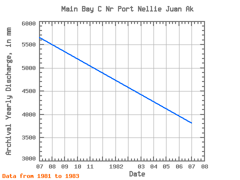
| Year | Jan | Feb | Mar | Apr | May | Jun | Jul | Aug | Sep | Oct | Nov | Dec | Annual | 1980 | 822.59 | 310.08 | 123.89 | 1981 | 499.63 | 232.89 | 261.42 | 165.32 | 626.92 | 344.61 | 493.94 | 974.00 | 691.61 | 607.07 | 424.71 | 356.54 | 5652.24 | 1982 | 48.85 | 116.93 | 62.45 | 143.49 | 377.16 | 809.93 | 389.45 | 326.48 | 730.45 | 218.52 | 160.42 | 431.20 | 3818.27 | 1983 | 248.77 | 290.15 | 77.29 | 172.05 | 584.84 | 401.51 | 292.13 | 364.86 | 197.40 | 276.92 | 391.61 | 183.46 | 3484.23 | 1984 | 266.03 | 32.84 | 285.11 | 179.58 | 376.35 | 323.17 | 255.20 | 197.97 | 488.41 |
|---|
 Return to R-Arctic Net Home Page