|
|
|||||||||||||||||
| Point ID: 9196 | Downloads | Plots | Site Data | Code: 15237000 |
|
|
|||||||||||||||||
| Download | |
|---|---|
| Site Descriptor Information | Site Time Series Data |
| Link to all available data | |
|
|
| View: | Statistics | Time Series |
| Units: | m3/s |
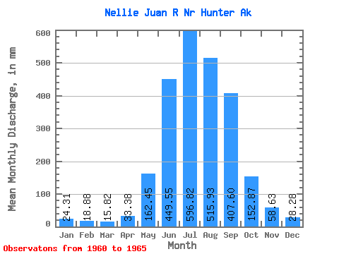
| Statistic | Jan | Feb | Mar | Apr | May | Jun | Jul | Aug | Sep | Oct | Nov | Dec | Annual |
|---|---|---|---|---|---|---|---|---|---|---|---|---|---|
| Mean | 24.31 | 19.04 | 15.82 | 33.37 | 162.42 | 449.55 | 596.73 | 515.85 | 407.61 | 152.84 | 58.63 | 28.28 | 2487.38 |
| Standard Deviation | 12.66 | 11.28 | 7.87 | 33.91 | 67.65 | 80.47 | 107.06 | 79.29 | 139.53 | 61.23 | 37.10 | 11.18 | 259.19 |
| Min | 12.76 | 8.03 | 7.26 | 10.58 | 71.28 | 348.27 | 483.14 | 401.19 | 254.00 | 99.22 | 29.50 | 16.16 | 2210.76 |
| Max | 43.63 | 33.45 | 25.35 | 93.40 | 239.44 | 565.02 | 758.36 | 572.32 | 592.12 | 225.60 | 110.08 | 38.06 | 2833.79 |
| Coefficient of Variation | 0.52 | 0.59 | 0.50 | 1.02 | 0.42 | 0.18 | 0.18 | 0.15 | 0.34 | 0.40 | 0.63 | 0.40 | 0.10 |
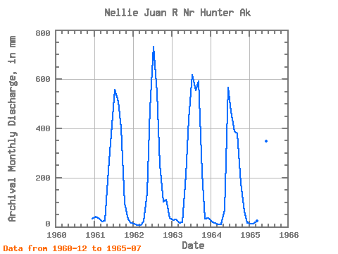
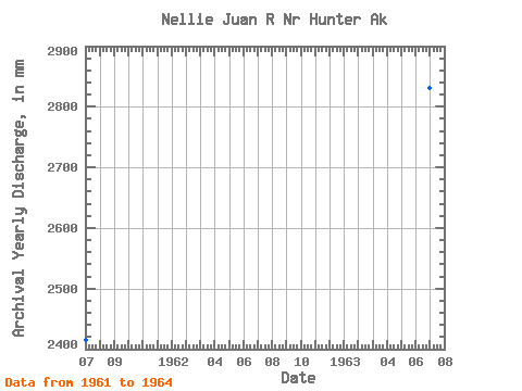
| Year | Jan | Feb | Mar | Apr | May | Jun | Jul | Aug | Sep | Oct | Nov | Dec | Annual | 1960 | 33.02 | 1961 | 43.63 | 33.45 | 21.83 | 23.74 | 239.44 | 415.10 | 577.58 | 524.53 | 404.21 | 99.22 | 29.50 | 16.16 | 2416.50 | 1962 | 12.76 | 8.03 | 7.26 | 21.16 | 143.16 | 481.08 | 758.36 | 565.36 | 254.00 | 105.23 | 110.08 | 37.86 | 2488.46 | 1963 | 28.55 | 28.64 | 15.71 | 17.99 | 218.75 | 438.25 | 637.22 | 572.32 | 592.12 | 225.60 | 33.59 | 38.06 | 2833.79 | 1964 | 22.98 | 13.84 | 8.93 | 10.58 | 71.28 | 565.02 | 483.14 | 401.19 | 380.09 | 181.32 | 61.34 | 16.31 | 2210.76 | 1965 | 13.61 | 11.23 | 25.35 | 93.40 | 139.48 | 348.27 | 527.35 |
|---|
 Return to R-Arctic Net Home Page