|
|
|||||||||||||||||
| Point ID: 9194 | Downloads | Plots | Site Data | Code: 15236000 |
|
|
|||||||||||||||||
| Download | |
|---|---|
| Site Descriptor Information | Site Time Series Data |
| Link to all available data | |

|

|
| View: | Statistics | Time Series |
| Units: | m3/s |
| Statistic | Jan | Feb | Mar | Apr | May | Jun | Jul | Aug | Sep | Oct | Nov | Dec | Annual |
|---|---|---|---|---|---|---|---|---|---|---|---|---|---|
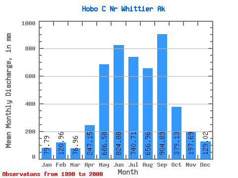
| Mean | 79.75 | 121.96 | 76.86 | 247.10 | 686.41 | 824.95 | 740.64 | 656.92 | 904.75 | 379.07 | 197.71 | 128.98 | 5135.39 |
| Standard Deviation | 34.88 | 78.48 | 41.86 | 77.79 | 187.98 | 197.34 | 261.00 | 188.14 | 801.66 | 116.37 | 134.37 | 77.71 | 1470.36 |
| Min | 46.05 | 36.51 | 30.63 | 114.61 | 443.94 | 422.99 | 378.88 | 380.89 | 257.94 | 192.24 | 47.09 | 39.62 | 3245.11 |
| Max | 140.30 | 245.72 | 164.48 | 366.11 | 1006.92 | 1078.73 | 1223.02 | 893.72 | 3058.05 | 546.42 | 440.38 | 269.07 | 8326.34 |
| Coefficient of Variation | 0.44 | 0.64 | 0.55 | 0.32 | 0.27 | 0.24 | 0.35 | 0.29 | 0.89 | 0.31 | 0.68 | 0.60 | 0.29 |
| Year | Jan | Feb | Mar | Apr | May | Jun | Jul | Aug | Sep | Oct | Nov | Dec | Annual | 1990 | 346.43 | 47.09 | 39.62 | 1991 | 49.06 | 45.19 | 39.12 | 243.30 | 774.87 | 1078.73 | 830.37 | 861.49 | 1085.96 | 375.38 | 186.42 | 117.49 | 5674.27 | 1992 | 46.05 | 39.01 | 44.85 | 283.09 | 443.94 | 422.99 | 378.88 | 753.14 | 257.94 | 431.71 | 440.38 | 96.56 | 3622.77 | 1993 | 64.86 | 164.04 | 99.14 | 309.63 | 929.39 | 754.82 | 617.64 | 893.72 | 867.33 | 546.42 | 251.37 | 269.07 | 5750.84 | 1994 | 131.04 | 179.06 | 118.04 | 366.11 | 821.39 | 866.81 | 739.47 | 380.89 | 649.04 | 440.15 | 106.81 | 57.56 | 4851.36 | 1995 | 140.30 | 138.80 | 65.38 | 290.66 | 1006.92 | 881.28 | 1223.02 | 818.95 | 3058.05 | 382.26 | 143.72 | 170.22 | 8326.34 | 1996 | 46.78 | 42.23 | 30.63 | 191.92 | 585.20 | 641.96 | 470.91 | 426.55 | 464.51 | 196.54 | 93.03 | 63.72 | 3245.11 | 1997 | 102.29 | 245.72 | 55.65 | 204.79 | 578.31 | 746.04 | 865.07 | 751.63 | 848.21 | 192.24 | 421.10 | 142.30 | 5156.77 | 1998 | 69.01 | 213.24 | 164.48 | 305.66 | 653.41 | 1067.87 | 756.63 | 663.23 | 667.99 | 366.76 | 145.41 | 90.88 | 5163.64 | 1999 | 91.04 | 36.51 | 56.52 | 114.61 | 498.21 | 838.38 | 500.52 | 552.11 | 855.08 | 512.86 | 141.81 | 242.39 | 4427.41 | 2000 | 57.13 | 115.77 | 94.74 | 161.27 | 572.46 | 950.55 | 1023.86 | 467.54 | 293.42 |
|---|
 Return to R-Arctic Net Home Page