|
|
|||||||||||||||||
| Point ID: 9190 | Downloads | Plots | Site Data | Code: 15219000 |
|
|
|||||||||||||||||
| Download | |
|---|---|
| Site Descriptor Information | Site Time Series Data |
| Link to all available data | |

|

|
| View: | Statistics | Time Series |
| Units: | m3/s |
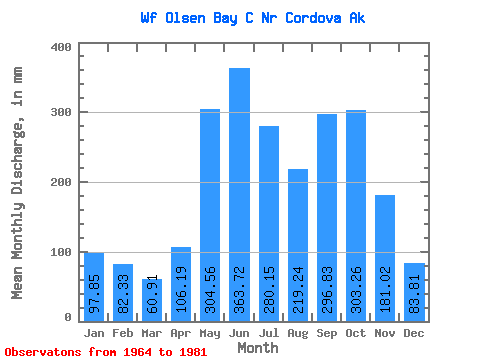
| Statistic | Jan | Feb | Mar | Apr | May | Jun | Jul | Aug | Sep | Oct | Nov | Dec | Annual |
|---|---|---|---|---|---|---|---|---|---|---|---|---|---|
| Mean | 97.91 | 83.07 | 60.95 | 106.18 | 304.52 | 363.74 | 280.15 | 219.28 | 296.78 | 303.30 | 180.96 | 83.83 | 2372.61 |
| Standard Deviation | 144.19 | 112.52 | 55.23 | 50.72 | 50.12 | 86.36 | 101.47 | 116.15 | 171.23 | 113.05 | 188.55 | 68.51 | 411.49 |
| Min | 8.38 | 10.22 | 9.28 | 11.48 | 219.19 | 245.24 | 117.92 | 86.38 | 106.70 | 123.00 | 18.55 | 14.54 | 1828.44 |
| Max | 478.01 | 420.84 | 157.62 | 209.33 | 405.99 | 578.89 | 502.34 | 457.49 | 646.77 | 497.32 | 819.01 | 241.86 | 3268.24 |
| Coefficient of Variation | 1.47 | 1.35 | 0.91 | 0.48 | 0.17 | 0.24 | 0.36 | 0.53 | 0.58 | 0.37 | 1.04 | 0.82 | 0.17 |
| Year | Jan | Feb | Mar | Apr | May | Jun | Jul | Aug | Sep | Oct | Nov | Dec | Annual | 1964 | 157.63 | 213.46 | 210.57 | 71.21 | 1965 | 8.38 | 35.53 | 85.11 | 147.09 | 249.35 | 386.72 | 320.06 | 232.99 | 370.34 | 283.88 | 48.36 | 35.60 | 2198.28 | 1966 | 15.09 | 10.22 | 13.19 | 82.06 | 263.57 | 339.38 | 183.36 | 457.49 | 646.77 | 230.01 | 115.91 | 23.05 | 2376.89 | 1967 | 15.14 | 13.30 | 14.00 | 61.33 | 239.30 | 269.90 | 224.61 | 229.25 | 633.35 | 123.00 | 250.33 | 131.09 | 2206.03 | 1968 | 50.13 | 246.89 | 137.08 | 84.23 | 405.99 | 251.97 | 169.53 | 86.38 | 179.36 | 176.78 | 102.52 | 76.45 | 1975.79 | 1969 | 35.99 | 37.32 | 157.62 | 187.44 | 359.27 | 277.41 | 192.00 | 99.19 | 106.70 | 356.47 | 202.67 | 241.86 | 2242.30 | 1970 | 141.21 | 172.33 | 145.40 | 117.79 | 305.59 | 409.59 | 287.67 | 447.24 | 212.49 | 274.18 | 134.09 | 48.68 | 2692.85 | 1971 | 47.44 | 28.40 | 16.67 | 58.98 | 219.19 | 578.89 | 502.34 | 290.61 | 172.05 | 290.79 | 115.47 | 38.89 | 2350.22 | 1972 | 21.79 | 13.40 | 9.28 | 11.48 | 311.48 | 355.94 | 261.54 | 189.59 | 450.75 | 382.32 | 83.84 | 32.85 | 2116.91 | 1973 | 21.81 | 18.81 | 26.07 | 80.03 | 343.46 | 388.27 | 290.26 | 329.46 | 119.24 | 160.77 | 30.60 | 30.71 | 1828.44 | 1974 | 16.76 | 13.00 | 11.46 | 100.13 | 279.34 | 245.24 | 117.92 | 93.97 | 282.14 | 479.45 | 276.79 | 95.33 | 2006.25 | 1975 | 43.84 | 22.09 | 14.18 | 104.54 | 359.44 | 413.36 | 364.99 | 122.46 | 402.41 | 223.09 | 18.55 | 14.54 | 2098.47 | 1976 | 15.97 | 14.83 | 16.11 | 94.55 | 293.15 | 423.42 | 245.56 | 177.59 | 463.57 | 466.37 | 819.01 | 236.53 | 3268.24 | 1977 | 478.01 | 420.84 | 60.69 | 209.33 | 292.75 | 427.54 | 301.71 | 188.00 | 278.99 | 279.53 | 55.05 | 38.95 | 3048.93 | 1978 | 99.11 | 80.79 | 68.09 | 122.90 | 297.88 | 321.18 | 227.41 | 98.67 | 174.93 | 399.48 | 89.29 | 92.78 | 2066.24 | 1979 | 31.33 | 18.86 | 137.50 | 133.17 | 297.48 | 306.43 | 344.90 | 247.97 | 254.70 | 497.32 | 351.78 | 81.48 | 2690.29 | 1980 | 183.54 | 181.97 | 62.70 | 159.63 | 355.09 | 424.59 | 448.56 | 217.60 | 139.88 | 319.19 | 171.43 | 135.06 | 2795.72 | 1981 | 438.96 | 83.63 | 50.38 |
|---|
 Return to R-Arctic Net Home Page