|
|
|||||||||||||||||
| Point ID: 9186 | Downloads | Plots | Site Data | Code: 15094000 |
|
|
|||||||||||||||||
| Download | |
|---|---|
| Site Descriptor Information | Site Time Series Data |
| Link to all available data | |
|
|
| View: | Statistics | Time Series |
| Units: | m3/s |
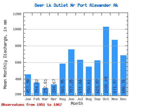
| Statistic | Jan | Feb | Mar | Apr | May | Jun | Jul | Aug | Sep | Oct | Nov | Dec | Annual |
|---|---|---|---|---|---|---|---|---|---|---|---|---|---|
| Mean | 457.98 | 357.86 | 292.74 | 334.72 | 583.82 | 757.35 | 631.53 | 550.53 | 623.95 | 1030.31 | 871.91 | 686.63 | 7261.20 |
| Standard Deviation | 167.15 | 144.69 | 98.62 | 141.21 | 195.51 | 207.91 | 189.19 | 206.77 | 253.32 | 348.55 | 250.07 | 273.42 | 876.67 |
| Min | 183.21 | 154.74 | 156.32 | 112.52 | 219.76 | 478.49 | 247.58 | 127.53 | 217.78 | 456.23 | 488.03 | 265.91 | 5485.86 |
| Max | 744.18 | 640.43 | 454.14 | 608.59 | 1017.21 | 1221.26 | 885.69 | 912.09 | 1080.83 | 1915.19 | 1345.88 | 1304.13 | 8793.10 |
| Coefficient of Variation | 0.36 | 0.40 | 0.34 | 0.42 | 0.34 | 0.28 | 0.30 | 0.38 | 0.41 | 0.34 | 0.29 | 0.40 | 0.12 |
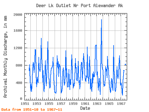
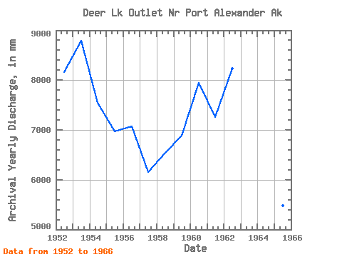
| Year | Jan | Feb | Mar | Apr | May | Jun | Jul | Aug | Sep | Oct | Nov | Dec | Annual | 1951 | 699.45 | 814.27 | 477.53 | 1952 | 214.68 | 335.67 | 200.54 | 462.82 | 731.19 | 868.42 | 854.03 | 652.08 | 897.99 | 1201.05 | 1155.23 | 592.51 | 8162.24 | 1953 | 315.92 | 486.55 | 454.14 | 395.93 | 1017.21 | 721.25 | 706.60 | 674.86 | 785.84 | 1473.08 | 970.48 | 808.90 | 8793.10 | 1954 | 428.47 | 640.43 | 250.49 | 191.01 | 469.49 | 906.77 | 727.80 | 336.76 | 429.28 | 817.58 | 1345.88 | 991.62 | 7555.41 | 1955 | 537.53 | 428.11 | 281.68 | 300.08 | 557.80 | 726.34 | 760.86 | 799.09 | 790.68 | 1018.36 | 488.03 | 303.75 | 6983.12 | 1956 | 183.21 | 169.38 | 156.32 | 206.42 | 714.36 | 1020.92 | 782.06 | 912.09 | 541.81 | 855.79 | 781.63 | 785.70 | 7081.56 | 1957 | 486.31 | 154.74 | 194.30 | 278.04 | 665.07 | 740.71 | 641.60 | 353.94 | 403.80 | 574.72 | 1135.98 | 541.48 | 6158.31 | 1958 | 744.18 | 302.01 | 308.45 | 306.58 | 732.46 | 478.49 | 247.58 | 491.92 | 352.45 | 831.32 | 1045.41 | 716.66 | 6539.99 | 1959 | 400.19 | 256.53 | 395.47 | 324.05 | 533.83 | 956.97 | 760.02 | 772.60 | 461.92 | 456.23 | 667.45 | 924.09 | 6888.57 | 1960 | 421.07 | 420.05 | 264.24 | 400.26 | 665.56 | 867.78 | 885.69 | 471.52 | 642.60 | 1107.31 | 950.86 | 860.00 | 7947.84 | 1961 | 625.82 | 430.39 | 440.95 | 557.75 | 547.97 | 1221.26 | 543.55 | 509.24 | 382.78 | 1033.78 | 698.18 | 265.91 | 7261.89 | 1962 | 499.42 | 277.09 | 205.51 | 608.59 | 403.63 | 648.86 | 559.17 | 552.06 | 654.58 | 1279.80 | 1263.81 | 1304.13 | 8238.74 | 1963 | 598.56 | 610.34 | 452.68 | 222.73 | 500.19 | 500.79 | 271.43 | 127.53 | 1080.83 | 1915.19 | 872.99 | 733.49 | 7891.04 | 1964 | 703.80 | 430.11 | 319.93 | 354.88 | 341.70 | 769.26 | 712.32 | 728.77 | 515.69 | 1043.32 | 727.74 | 767.38 | 7400.34 | 1965 | 531.67 | 289.30 | 260.17 | 167.71 | 219.76 | 500.67 | 441.87 | 315.72 | 217.78 | 1299.55 | 697.39 | 563.66 | 5485.86 | 1966 | 231.49 | 182.88 | 315.84 | 466.10 | 794.51 | 601.20 | 510.35 | 632.95 | 792.33 | 1057.34 | 615.07 | 349.22 | 6529.99 | 1967 | 405.29 | 312.19 | 183.07 | 112.52 | 446.43 | 587.95 | 699.49 | 477.39 | 1032.78 | 851.45 | 592.15 |
|---|
 Return to R-Arctic Net Home Page