|
|
|||||||||||||||||
| Point ID: 9180 | Downloads | Plots | Site Data | Code: 15088200 |
|
|
|||||||||||||||||
| Download | |
|---|---|
| Site Descriptor Information | Site Time Series Data |
| Link to all available data | |
|
|
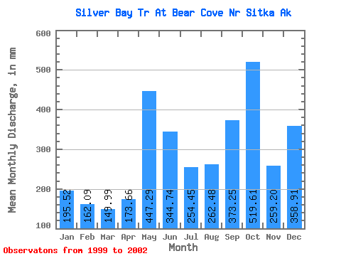
| View: | Statistics | Time Series |
| Units: | m3/s |
| Statistic | Jan | Feb | Mar | Apr | May | Jun | Jul | Aug | Sep | Oct | Nov | Dec | Annual |
|---|---|---|---|---|---|---|---|---|---|---|---|---|---|
| Mean | 194.51 | 163.49 | 150.34 | 174.76 | 447.71 | 345.66 | 253.52 | 263.25 | 372.64 | 518.29 | 259.11 | 358.33 | 3319.82 |
| Standard Deviation | 58.39 | 75.30 | 78.05 | 19.95 | 66.21 | 106.21 | 113.00 | 211.22 | 130.84 | 97.95 | 66.16 | 203.98 | 67.19 |
| Min | 127.16 | 77.58 | 62.11 | 155.52 | 389.26 | 242.87 | 147.29 | 34.81 | 223.26 | 405.33 | 209.35 | 192.12 | 3272.31 |
| Max | 230.91 | 218.03 | 210.35 | 195.35 | 519.62 | 454.98 | 372.24 | 451.46 | 466.90 | 579.57 | 334.19 | 585.96 | 3367.33 |
| Coefficient of Variation | 0.30 | 0.46 | 0.52 | 0.11 | 0.15 | 0.31 | 0.45 | 0.80 | 0.35 | 0.19 | 0.26 | 0.57 | 0.02 |
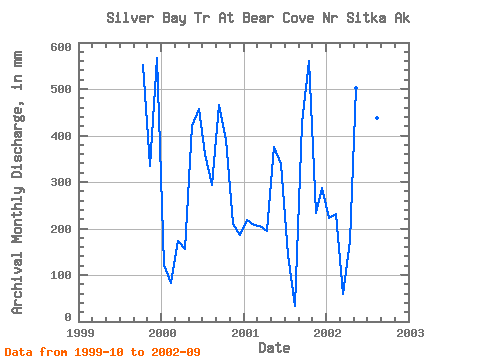
| Year | Jan | Feb | Mar | Apr | May | Jun | Jul | Aug | Sep | Oct | Nov | Dec | Annual | 1999 | 569.98 | 334.19 | 585.96 | 2000 | 127.16 | 77.58 | 178.56 | 155.52 | 434.27 | 454.98 | 372.24 | 303.48 | 466.90 | 405.33 | 209.35 | 192.12 | 3367.33 | 2001 | 225.47 | 194.85 | 210.35 | 195.35 | 389.26 | 339.12 | 147.29 | 34.81 | 427.77 | 579.57 | 233.80 | 296.91 | 3272.31 | 2002 | 230.91 | 218.03 | 62.11 | 173.41 | 519.62 | 242.87 | 241.02 | 451.46 | 223.26 |
|---|
 Return to R-Arctic Net Home Page