|
|
|||||||||||||||||
| Point ID: 9177 | Downloads | Plots | Site Data | Code: 15100000 |
|
|
|||||||||||||||||
| Download | |
|---|---|
| Site Descriptor Information | Site Time Series Data |
| Link to all available data | |

|

|
| View: | Statistics | Time Series |
| Units: | m3/s |
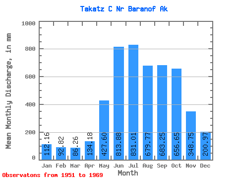
| Statistic | Jan | Feb | Mar | Apr | May | Jun | Jul | Aug | Sep | Oct | Nov | Dec | Annual |
|---|---|---|---|---|---|---|---|---|---|---|---|---|---|
| Mean | 112.16 | 93.62 | 86.27 | 134.18 | 427.52 | 813.87 | 830.92 | 679.65 | 683.26 | 656.54 | 348.75 | 200.94 | 5087.50 |
| Standard Deviation | 72.48 | 65.31 | 49.44 | 41.84 | 114.13 | 142.49 | 120.05 | 111.21 | 228.96 | 216.88 | 123.61 | 120.51 | 450.50 |
| Min | 31.81 | 30.49 | 28.43 | 54.27 | 241.06 | 586.58 | 589.93 | 470.50 | 435.04 | 391.56 | 162.72 | 61.83 | 4232.76 |
| Max | 294.41 | 298.78 | 237.66 | 200.43 | 623.54 | 1072.01 | 1015.27 | 905.96 | 1263.03 | 1127.90 | 649.77 | 469.10 | 5950.10 |
| Coefficient of Variation | 0.65 | 0.70 | 0.57 | 0.31 | 0.27 | 0.17 | 0.14 | 0.16 | 0.34 | 0.33 | 0.35 | 0.60 | 0.09 |
| Year | Jan | Feb | Mar | Apr | May | Jun | Jul | Aug | Sep | Oct | Nov | Dec | Annual | 1951 | 814.22 | 516.35 | 511.24 | 445.66 | 366.12 | 89.80 | 1952 | 33.46 | 30.49 | 28.43 | 129.73 | 351.21 | 640.00 | 982.47 | 703.08 | 780.90 | 775.23 | 459.88 | 192.45 | 5084.24 | 1953 | 94.60 | 89.38 | 115.18 | 146.42 | 623.54 | 886.82 | 875.94 | 739.16 | 739.86 | 869.24 | 366.72 | 215.56 | 5737.42 | 1954 | 83.16 | 191.37 | 59.72 | 54.27 | 397.93 | 814.61 | 716.14 | 597.99 | 590.75 | 475.84 | 649.77 | 343.87 | 4973.32 | 1955 | 105.19 | 72.12 | 65.50 | 87.70 | 241.06 | 601.00 | 910.70 | 780.25 | 691.14 | 472.55 | 162.72 | 61.83 | 4232.76 | 1956 | 38.13 | 36.63 | 41.85 | 103.48 | 459.97 | 756.33 | 906.74 | 905.96 | 484.94 | 421.09 | 360.67 | 330.97 | 4818.94 | 1957 | 110.86 | 61.40 | 55.84 | 106.28 | 503.55 | 829.51 | 749.31 | 608.41 | 564.33 | 391.56 | 490.45 | 122.36 | 4582.28 | 1958 | 218.16 | 69.22 | 83.71 | 191.52 | 533.14 | 847.82 | 633.85 | 645.03 | 435.04 | 760.48 | 332.96 | 185.33 | 4913.31 | 1959 | 79.27 | 68.47 | 104.76 | 125.41 | 464.19 | 984.62 | 971.41 | 733.92 | 477.76 | 450.79 | 302.61 | 181.28 | 4924.03 | 1960 | 82.79 | 98.19 | 80.03 | 154.25 | 622.35 | 835.51 | 987.79 | 640.34 | 662.68 | 872.11 | 327.77 | 327.73 | 5663.44 | 1961 | 142.24 | 109.93 | 145.21 | 173.15 | 479.09 | 949.35 | 823.85 | 781.71 | 575.78 | 688.99 | 196.32 | 75.66 | 5121.37 | 1962 | 125.44 | 67.88 | 62.43 | 194.60 | 260.71 | 656.04 | 762.14 | 768.91 | 726.96 | 739.91 | 478.41 | 469.10 | 5290.81 | 1963 | 294.41 | 298.78 | 117.23 | 143.23 | 405.49 | 586.58 | 589.93 | 470.50 | 1263.03 | 1127.90 | 298.56 | 357.91 | 5950.10 | 1964 | 171.66 | 132.23 | 82.61 | 145.98 | 321.62 | 1016.87 | 1015.27 | 826.20 | 519.72 | 758.87 | 315.03 | 250.57 | 5534.78 | 1965 | 215.57 | 76.32 | 98.98 | 138.69 | 241.38 | 668.74 | 819.36 | 560.63 | 451.29 | 983.94 | 188.71 | 135.01 | 4551.00 | 1966 | 38.40 | 47.55 | 98.23 | 140.64 | 411.05 | 781.82 | 850.04 | 690.18 | 887.95 | 589.09 | 221.66 | 79.60 | 4820.28 | 1967 | 89.53 | 69.62 | 37.63 | 60.00 | 419.21 | 842.63 | 784.30 | 738.29 | 1111.28 | 518.18 | 454.21 | 105.89 | 5224.12 | 1968 | 64.10 | 133.81 | 237.66 | 119.41 | 507.98 | 879.36 | 704.32 | 610.15 | 940.45 | 476.23 | 304.88 | 91.97 | 5065.37 | 1969 | 31.81 | 31.76 | 37.80 | 200.43 | 451.98 | 1072.01 | 889.65 | 596.27 | 566.82 |
|---|
 Return to R-Arctic Net Home Page