|
|
|||||||||||||||||
| Point ID: 9176 | Downloads | Plots | Site Data | Code: 15087700 |
|
|
|||||||||||||||||
| Download | |
|---|---|
| Site Descriptor Information | Site Time Series Data |
| Link to all available data | |
|
|
| View: | Statistics | Time Series |
| Units: | m3/s |
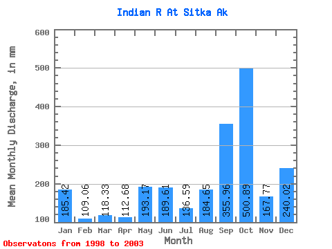
| Statistic | Jan | Feb | Mar | Apr | May | Jun | Jul | Aug | Sep | Oct | Nov | Dec | Annual |
|---|---|---|---|---|---|---|---|---|---|---|---|---|---|
| Mean | 185.41 | 110.01 | 118.31 | 112.68 | 193.16 | 189.58 | 136.59 | 184.62 | 355.97 | 500.85 | 167.78 | 239.97 | 2585.32 |
| Standard Deviation | 68.23 | 60.34 | 84.91 | 88.51 | 103.02 | 78.25 | 29.61 | 167.74 | 148.79 | 101.56 | 50.99 | 195.84 | 422.38 |
| Min | 135.92 | 52.44 | 60.40 | 35.77 | 48.60 | 87.64 | 90.07 | 53.57 | 186.13 | 344.04 | 89.76 | 124.43 | 2251.24 |
| Max | 304.16 | 183.68 | 261.30 | 254.26 | 338.46 | 307.52 | 165.07 | 478.07 | 530.15 | 604.16 | 207.05 | 586.31 | 3198.80 |
| Coefficient of Variation | 0.37 | 0.55 | 0.72 | 0.79 | 0.53 | 0.41 | 0.22 | 0.91 | 0.42 | 0.20 | 0.30 | 0.82 | 0.16 |
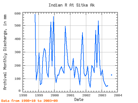
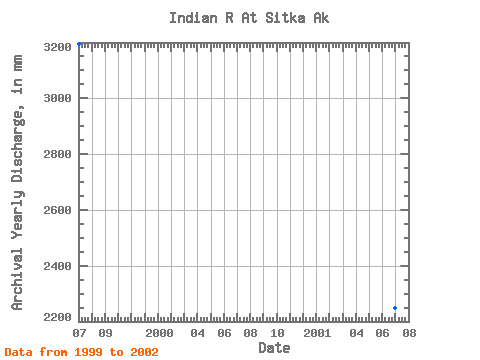
| Year | Jan | Feb | Mar | Apr | May | Jun | Jul | Aug | Sep | Oct | Nov | Dec | Annual | 1998 | 604.16 | 89.76 | 162.82 | 1999 | 304.16 | 52.44 | 68.67 | 254.26 | 338.46 | 307.52 | 152.41 | 114.21 | 300.42 | 544.06 | 194.07 | 586.31 | 3198.80 | 2000 | 144.72 | 65.50 | 131.82 | 126.42 | 176.27 | 189.82 | 165.07 | 144.73 | 493.34 | 344.04 | 205.64 | 197.51 | 2381.54 | 2001 | 169.67 | 165.66 | 261.30 | 105.97 | 197.42 | 176.22 | 125.89 | 53.57 | 269.82 | 460.84 | 142.38 | 124.43 | 2251.24 | 2002 | 135.92 | 183.68 | 69.37 | 35.77 | 205.06 | 186.68 | 149.49 | 478.07 | 186.13 | 551.14 | 207.05 | 128.76 | 2509.70 | 2003 | 172.57 | 82.76 | 60.40 | 40.98 | 48.60 | 87.64 | 90.07 | 132.54 | 530.15 |
|---|
 Return to R-Arctic Net Home Page