|
|
|||||||||||||||||
| Point ID: 9167 | Downloads | Plots | Site Data | Code: 15086960 |
|
|
|||||||||||||||||
| Download | |
|---|---|
| Site Descriptor Information | Site Time Series Data |
| Link to all available data | |
|
|
| View: | Statistics | Time Series |
| Units: | m3/s |
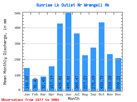
| Statistic | Jan | Feb | Mar | Apr | May | Jun | Jul | Aug | Sep | Oct | Nov | Dec | Annual |
|---|---|---|---|---|---|---|---|---|---|---|---|---|---|
| Mean | 146.10 | 77.23 | 92.65 | 157.56 | 426.59 | 495.64 | 365.54 | 227.42 | 275.46 | 433.42 | 233.18 | 208.31 | 3198.93 |
| Standard Deviation | 76.71 | 40.82 | 38.47 | 54.16 | 78.15 | 178.28 | 190.26 | 110.37 | 92.52 | 110.05 | 97.09 | 97.31 | 703.16 |
| Min | 55.34 | 35.67 | 59.72 | 81.63 | 266.77 | 233.87 | 144.27 | 84.94 | 166.61 | 284.86 | 100.36 | 102.77 | 2592.96 |
| Max | 233.55 | 152.94 | 161.32 | 232.19 | 485.63 | 747.50 | 653.95 | 372.80 | 414.13 | 606.91 | 378.77 | 367.20 | 4228.72 |
| Coefficient of Variation | 0.53 | 0.53 | 0.41 | 0.34 | 0.18 | 0.36 | 0.52 | 0.48 | 0.34 | 0.25 | 0.42 | 0.47 | 0.22 |
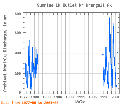
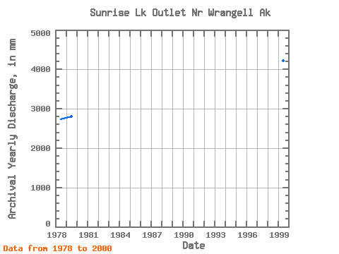
| Year | Jan | Feb | Mar | Apr | May | Jun | Jul | Aug | Sep | Oct | Nov | Dec | Annual | 1977 | 166.61 | 447.57 | 143.23 | 106.76 | 1978 | 100.82 | 71.88 | 59.72 | 139.30 | 485.63 | 386.15 | 160.68 | 193.06 | 201.17 | 545.41 | 259.59 | 150.37 | 2743.53 | 1979 | 55.34 | 35.67 | 107.73 | 214.19 | 427.62 | 457.81 | 355.05 | 84.94 | 235.71 | 306.39 | 243.09 | 286.89 | 2801.08 | 1980 | 230.60 | 152.94 | 161.32 | 232.19 | 471.76 | 424.06 | 279.89 | 207.00 | 254.74 | 405.13 | 378.77 | 1997 | 397.38 | 139.27 | 232.27 | 1998 | 85.02 | 106.20 | 120.27 | 172.10 | 470.20 | 233.87 | 144.27 | 327.46 | 267.73 | 473.71 | 100.36 | 102.77 | 2592.96 | 1999 | 233.55 | 42.98 | 71.37 | 156.02 | 474.60 | 747.50 | 546.83 | 300.52 | 414.13 | 606.91 | 287.01 | 367.20 | 4228.72 | 2000 | 103.08 | 55.02 | 64.46 | 107.44 | 389.55 | 693.79 | 653.95 | 372.80 | 388.13 | 284.86 | 314.11 | 211.93 | 3628.33 | 2001 | 214.27 | 75.90 | 63.68 | 81.63 | 266.77 | 526.32 | 418.11 | 106.15 |
|---|
 Return to R-Arctic Net Home Page