|
|
|||||||||||||||||
| Point ID: 9158 | Downloads | Plots | Site Data | Code: 15108800 |
|
|
|||||||||||||||||
| Download | |
|---|---|
| Site Descriptor Information | Site Time Series Data |
| Link to all available data | |
|
|
| View: | Statistics | Time Series |
| Units: | m3/s |
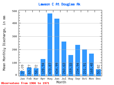
| Statistic | Jan | Feb | Mar | Apr | May | Jun | Jul | Aug | Sep | Oct | Nov | Dec | Annual |
|---|---|---|---|---|---|---|---|---|---|---|---|---|---|
| Mean | 37.06 | 63.68 | 58.66 | 128.98 | 473.95 | 435.14 | 260.66 | 159.35 | 234.95 | 201.96 | 168.56 | 50.84 | 1909.28 |
| Standard Deviation | 22.36 | 50.68 | 51.49 | 44.67 | 212.54 | 455.68 | 194.66 | 95.02 | 100.56 | 100.06 | 97.08 | 37.03 | 372.91 |
| Min | 9.10 | 6.77 | 10.71 | 69.94 | 277.85 | 97.09 | 47.72 | 43.58 | 153.14 | 69.00 | 89.17 | 1.74 | 1576.59 |
| Max | 55.86 | 124.72 | 121.81 | 187.32 | 777.19 | 1233.67 | 575.43 | 292.45 | 362.70 | 342.67 | 337.86 | 97.78 | 2437.05 |
| Coefficient of Variation | 0.60 | 0.80 | 0.88 | 0.35 | 0.45 | 1.05 | 0.75 | 0.60 | 0.43 | 0.49 | 0.58 | 0.73 | 0.20 |
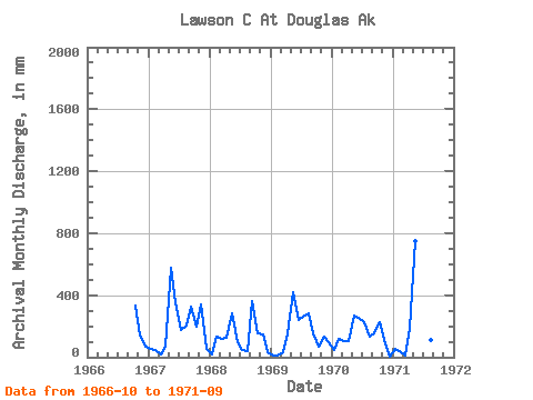
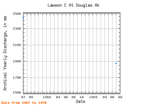
| Year | Jan | Feb | Mar | Apr | May | Jun | Jul | Aug | Sep | Oct | Nov | Dec | Annual | 1966 | 342.67 | 136.92 | 71.38 | 1967 | 52.86 | 42.00 | 19.12 | 69.94 | 594.32 | 353.81 | 182.31 | 209.88 | 324.32 | 201.49 | 337.86 | 53.46 | 2437.05 | 1968 | 16.52 | 124.72 | 121.81 | 128.61 | 289.81 | 97.09 | 47.72 | 43.58 | 362.70 | 162.62 | 143.77 | 29.83 | 1576.59 | 1969 | 9.10 | 6.77 | 35.78 | 152.90 | 430.60 | 236.75 | 268.14 | 292.45 | 155.14 | 69.00 | 135.07 | 97.78 | 1878.58 | 1970 | 50.96 | 109.10 | 105.88 | 106.15 | 277.85 | 254.38 | 229.69 | 133.92 | 153.14 | 234.00 | 89.17 | 1.74 | 1744.90 | 1971 | 55.86 | 35.83 | 10.71 | 187.32 | 777.19 | 1233.67 | 575.43 | 116.92 | 179.42 |
|---|
 Return to R-Arctic Net Home Page