|
|
|||||||||||||||||
| Point ID: 9154 | Downloads | Plots | Site Data | Code: 15106980 |
|
|
|||||||||||||||||
| Download | |
|---|---|
| Site Descriptor Information | Site Time Series Data |
| Link to all available data | |

|

|
| View: | Statistics | Time Series |
| Units: | m3/s |
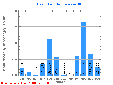
| Statistic | Jan | Feb | Mar | Apr | May | Jun | Jul | Aug | Sep | Oct | Nov | Dec | Annual |
|---|---|---|---|---|---|---|---|---|---|---|---|---|---|
| Mean | 148.25 | 126.29 | 105.19 | 174.37 | 323.94 | 214.35 | 103.21 | 102.83 | 220.61 | 429.43 | 235.07 | 154.55 | 2323.51 |
| Standard Deviation | 131.77 | 106.31 | 63.59 | 63.27 | 107.52 | 101.97 | 43.67 | 60.74 | 108.98 | 192.97 | 130.26 | 105.38 | 348.46 |
| Min | 20.98 | 17.91 | 33.69 | 60.25 | 127.65 | 66.44 | 33.40 | 28.45 | 63.52 | 179.63 | 50.23 | 28.18 | 1771.71 |
| Max | 437.34 | 376.11 | 259.40 | 294.89 | 576.42 | 435.76 | 188.39 | 270.90 | 558.94 | 999.31 | 410.32 | 417.09 | 2965.14 |
| Coefficient of Variation | 0.89 | 0.84 | 0.60 | 0.36 | 0.33 | 0.48 | 0.42 | 0.59 | 0.49 | 0.45 | 0.55 | 0.68 | 0.15 |
| Year | Jan | Feb | Mar | Apr | May | Jun | Jul | Aug | Sep | Oct | Nov | Dec | Annual | 1968 | 90.26 | 33.40 | 45.90 | 558.94 | 416.57 | 373.68 | 78.40 | 1969 | 22.30 | 17.91 | 48.60 | 234.18 | 391.98 | 204.51 | 110.89 | 138.71 | 157.87 | 179.63 | 409.15 | 234.47 | 2146.18 | 1970 | 53.02 | 254.97 | 186.07 | 158.96 | 285.09 | 213.42 | 177.63 | 118.67 | 305.31 | 266.68 | 121.69 | 152.04 | 2302.90 | 1971 | 123.48 | 54.27 | 51.71 | 99.88 | 333.43 | 351.70 | 87.61 | 82.89 | 265.49 | 251.91 | 214.92 | 36.37 | 1954.24 | 1972 | 42.09 | 27.74 | 75.33 | 78.08 | 576.42 | 435.76 | 155.55 | 198.82 | 275.63 | 620.99 | 195.14 | 54.00 | 2721.26 | 1973 | 54.14 | 71.73 | 66.17 | 207.12 | 371.68 | 286.44 | 118.30 | 178.20 | 163.38 | 304.80 | 50.23 | 70.72 | 1937.96 | 1974 | 20.98 | 139.98 | 33.69 | 190.71 | 388.99 | 245.25 | 106.62 | 54.98 | 173.92 | 657.10 | 349.49 | 188.61 | 2549.29 | 1975 | 63.43 | 34.00 | 39.82 | 60.25 | 395.50 | 337.45 | 139.38 | 65.58 | 206.27 | 216.84 | 86.60 | 132.72 | 1771.71 | 1976 | 111.12 | 79.65 | 97.20 | 176.66 | 492.76 | 344.67 | 188.39 | 71.57 | 222.99 | 463.36 | 407.20 | 208.71 | 2858.11 | 1977 | 198.37 | 313.44 | 135.97 | 276.67 | 219.77 | 161.11 | 67.38 | 28.45 | 192.46 | 465.50 | 115.37 | 28.18 | 2217.54 | 1978 | 55.79 | 59.20 | 86.20 | 199.17 | 253.92 | 111.46 | 71.30 | 44.43 | 115.75 | 999.31 | 350.19 | 232.71 | 2564.18 | 1979 | 38.06 | 18.53 | 72.41 | 197.94 | 385.93 | 203.79 | 132.76 | 81.45 | 124.48 | 513.57 | 241.26 | 97.19 | 2096.43 | 1980 | 65.12 | 76.55 | 77.03 | 294.89 | 258.74 | 137.17 | 91.24 | 114.69 | 173.73 | 591.64 | 347.27 | 100.97 | 2325.67 | 1981 | 437.34 | 129.81 | 140.92 | 105.09 | 127.65 | 73.07 | 107.62 | 125.11 | 373.75 | 331.21 | 410.32 | 156.47 | 2516.99 | 1982 | 111.64 | 27.23 | 46.25 | 128.70 | 408.96 | 202.04 | 57.34 | 38.59 | 167.03 | 440.51 | 175.23 | 89.65 | 1883.76 | 1983 | 193.29 | 99.36 | 89.59 | 250.84 | 270.12 | 66.44 | 41.10 | 270.90 | 262.42 | 368.23 | 94.34 | 34.93 | 2036.46 | 1984 | 355.42 | 286.47 | 259.40 | 143.60 | 160.83 | 131.43 | 110.89 | 140.65 | 111.86 | 232.46 | 138.54 | 164.15 | 2240.15 | 1985 | 423.86 | 376.11 | 89.46 | 140.75 | 348.26 | 333.60 | 158.62 | 97.07 | 150.05 | 345.85 | 78.54 | 417.09 | 2965.14 | 1986 | 259.52 | 113.47 | 230.63 | 152.66 | 249.24 | 201.19 | 66.31 | 94.14 | 63.52 | 372.40 | 152.01 | 328.99 | 2272.55 | 1987 | 239.94 | 150.55 | 105.59 | 214.33 | 266.29 | 215.83 | 62.04 | 37.28 | 269.52 | 550.01 | 390.22 | 284.63 | 2786.19 | 1988 | 96.03 | 194.84 | 171.82 | 176.99 | 293.21 | 154.73 | 83.05 | 131.43 | 298.47 |
|---|
 Return to R-Arctic Net Home Page