|
|
|||||||||||||||||
| Point ID: 9153 | Downloads | Plots | Site Data | Code: 15106970 |
|
|
|||||||||||||||||
| Download | |
|---|---|
| Site Descriptor Information | Site Time Series Data |
| Link to all available data | |
|
|
| View: | Statistics | Time Series |
| Units: | m3/s |
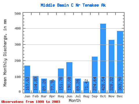
| Statistic | Jan | Feb | Mar | Apr | May | Jun | Jul | Aug | Sep | Oct | Nov | Dec | Annual |
|---|---|---|---|---|---|---|---|---|---|---|---|---|---|
| Mean | 173.49 | 107.72 | 92.58 | 73.73 | 155.21 | 191.09 | 91.05 | 70.61 | 220.95 | 429.20 | 328.03 | 384.28 | 1946.73 |
| Standard Deviation | 65.21 | 26.33 | 27.66 | 25.56 | 54.97 | 106.91 | 43.00 | 31.25 | 70.98 | 217.73 | 214.25 | 381.53 | 115.01 |
| Min | 118.06 | 69.83 | 64.50 | 43.49 | 105.39 | 58.46 | 44.63 | 26.20 | 144.00 | 292.85 | 201.31 | 112.88 | 1845.65 |
| Max | 245.05 | 130.71 | 127.56 | 105.12 | 231.81 | 319.39 | 160.68 | 101.07 | 328.90 | 753.58 | 648.58 | 947.96 | 2071.87 |
| Coefficient of Variation | 0.38 | 0.24 | 0.30 | 0.35 | 0.35 | 0.56 | 0.47 | 0.44 | 0.32 | 0.51 | 0.65 | 0.99 | 0.06 |
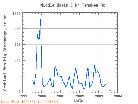
| Year | Jan | Feb | Mar | Apr | May | Jun | Jul | Aug | Sep | Oct | Nov | Dec | Annual | 1999 | 160.68 | 95.60 | 247.10 | 753.58 | 648.58 | 947.96 | 2000 | 118.35 | 69.83 | 100.50 | 105.12 | 155.21 | 182.59 | 89.27 | 77.75 | 328.90 | 292.85 | 201.31 | 202.15 | 1922.68 | 2001 | 212.51 | 130.71 | 127.56 | 67.68 | 128.43 | 203.90 | 89.27 | 52.41 | 180.86 | 316.18 | 223.49 | 112.88 | 1845.65 | 2002 | 118.06 | 116.77 | 64.50 | 43.49 | 231.81 | 319.39 | 71.41 | 101.07 | 144.00 | 354.19 | 238.75 | 274.13 | 2071.87 | 2003 | 245.05 | 113.58 | 77.75 | 78.62 | 105.39 | 58.46 | 44.63 | 26.20 | 203.90 |
|---|
 Return to R-Arctic Net Home Page