|
|
|||||||||||||||||
| Point ID: 9152 | Downloads | Plots | Site Data | Code: 15087000 |
|
|
|||||||||||||||||
| Download | |
|---|---|
| Site Descriptor Information | Site Time Series Data |
| Link to all available data | |
|
|
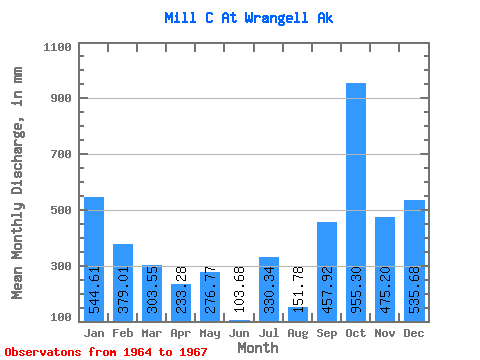
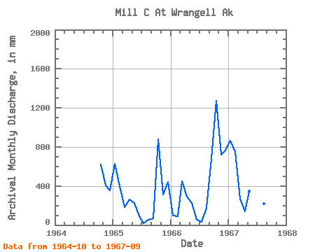
| View: | Statistics | Time Series |
| Units: | m3/s |
| Statistic | Jan | Feb | Mar | Apr | May | Jun | Jul | Aug | Sep | Oct | Nov | Dec | Annual |
|---|---|---|---|---|---|---|---|---|---|---|---|---|---|
| Mean | 548.75 | 385.37 | 306.39 | 229.44 | 275.96 | 100.22 | 327.31 | 154.06 | 454.85 | 957.84 | 476.83 | 536.66 | 4256.60 |
| Standard Deviation | 405.59 | 312.23 | 142.62 | 81.17 | 72.25 | 54.88 | 520.61 | 87.01 | 336.80 | 338.39 | 214.46 | 220.94 | 935.96 |
| Min | 101.36 | 80.75 | 183.43 | 138.53 | 232.67 | 55.01 | 17.85 | 57.59 | 67.68 | 643.87 | 308.45 | 368.87 | 3594.78 |
| Max | 892.38 | 704.70 | 462.75 | 294.62 | 359.37 | 161.28 | 928.37 | 226.62 | 680.26 | 1316.26 | 718.27 | 786.99 | 4918.42 |
| Coefficient of Variation | 0.74 | 0.81 | 0.47 | 0.35 | 0.26 | 0.55 | 1.59 | 0.56 | 0.74 | 0.35 | 0.45 | 0.41 | 0.22 |
| Year | Jan | Feb | Mar | Apr | May | Jun | Jul | Aug | Sep | Oct | Nov | Dec | Annual | 1964 | 643.87 | 403.78 | 368.87 | 1965 | 652.51 | 370.65 | 183.43 | 255.17 | 232.67 | 84.38 | 17.85 | 57.59 | 67.68 | 913.40 | 308.45 | 454.11 | 3594.78 | 1966 | 101.36 | 80.75 | 462.75 | 294.62 | 235.84 | 55.01 | 35.71 | 177.96 | 680.26 | 1316.26 | 718.27 | 786.99 | 4918.42 | 1967 | 892.38 | 704.70 | 272.98 | 138.53 | 359.37 | 161.28 | 928.37 | 226.62 | 616.61 |
|---|
 Return to R-Arctic Net Home Page