|
|
|||||||||||||||||
| Point ID: 9151 | Downloads | Plots | Site Data | Code: 15100510 |
|
|
|||||||||||||||||
| Download | |
|---|---|
| Site Descriptor Information | Site Time Series Data |
| Link to all available data | |
|
|
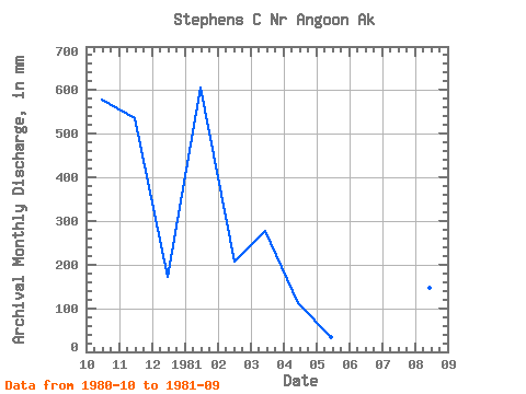
| View: | Statistics | Time Series |
| Units: | m3/s |
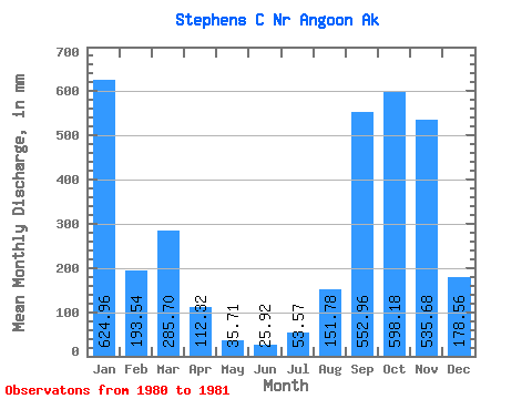
| Statistic | Jan | Feb | Mar | Apr | May | Jun | Jul | Aug | Sep | Oct | Nov | Dec | Annual |
|---|---|---|---|---|---|---|---|---|---|---|---|---|---|
| Mean | 626.31 | 192.88 | 281.91 | 114.05 | 31.96 | 25.92 | 53.56 | 147.43 | 556.42 | 596.65 | 532.22 | 179.11 | |
| Standard Deviation | |||||||||||||
| Min | 626.31 | 192.88 | 281.91 | 114.05 | 31.96 | 25.92 | 53.56 | 147.43 | 556.42 | 596.65 | 532.22 | 179.11 | |
| Max | 626.31 | 192.88 | 281.91 | 114.05 | 31.96 | 25.92 | 53.56 | 147.43 | 556.42 | 596.65 | 532.22 | 179.11 | |
| Coefficient of Variation |
| Year | Jan | Feb | Mar | Apr | May | Jun | Jul | Aug | Sep | Oct | Nov | Dec | Annual | 1980 | 596.65 | 532.22 | 179.11 | 1981 | 626.31 | 192.88 | 281.91 | 114.05 | 31.96 | 25.92 | 53.56 | 147.43 | 556.42 |
|---|
 Return to R-Arctic Net Home Page