|
|
|||||||||||||||||
| Point ID: 9144 | Downloads | Plots | Site Data | Code: 15106100 |
|
|
|||||||||||||||||
| Download | |
|---|---|
| Site Descriptor Information | Site Time Series Data |
| Link to all available data | |
|
|
| View: | Statistics | Time Series |
| Units: | m3/s |
| Statistic | Jan | Feb | Mar | Apr | May | Jun | Jul | Aug | Sep | Oct | Nov | Dec | Annual |
|---|---|---|---|---|---|---|---|---|---|---|---|---|---|
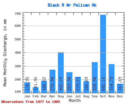
| Mean | 178.93 | 143.12 | 188.58 | 273.99 | 402.03 | 253.99 | 219.17 | 186.65 | 328.98 | 682.06 | 314.72 | 167.66 | 3485.87 |
| Standard Deviation | 159.38 | 103.65 | 67.58 | 119.19 | 130.07 | 79.80 | 51.17 | 67.65 | 136.42 | 209.33 | 85.61 | 88.07 | 378.74 |
| Min | 44.84 | 19.60 | 100.86 | 175.00 | 171.46 | 111.85 | 148.80 | 130.84 | 216.56 | 458.24 | 174.78 | 72.85 | 3038.87 |
| Max | 454.77 | 268.48 | 276.69 | 471.42 | 482.90 | 296.57 | 290.61 | 261.52 | 562.71 | 1010.78 | 381.36 | 267.63 | 3867.20 |
| Coefficient of Variation | 0.89 | 0.72 | 0.36 | 0.43 | 0.32 | 0.31 | 0.23 | 0.36 | 0.41 | 0.31 | 0.27 | 0.53 | 0.11 |
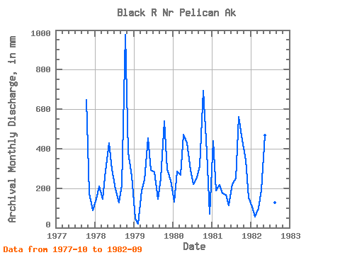
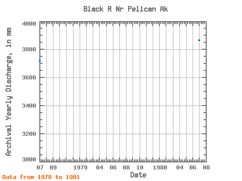
| Year | Jan | Feb | Mar | Apr | May | Jun | Jul | Aug | Sep | Oct | Nov | Dec | Annual | 1977 | 666.63 | 174.78 | 92.04 | 1978 | 150.82 | 197.37 | 148.15 | 289.27 | 441.65 | 296.57 | 202.10 | 130.95 | 216.56 | 1010.78 | 379.94 | 267.63 | 3722.37 | 1979 | 44.84 | 19.60 | 194.93 | 243.05 | 470.17 | 291.57 | 290.61 | 151.09 | 250.62 | 557.05 | 296.30 | 246.72 | 3038.87 | 1980 | 134.20 | 268.48 | 276.69 | 471.42 | 443.98 | 292.78 | 227.17 | 261.52 | 315.11 | 717.58 | 381.36 | 72.85 | 3867.20 | 1981 | 454.77 | 176.24 | 222.26 | 175.00 | 171.46 | 111.85 | 227.17 | 258.88 | 562.71 | 458.24 | 341.22 | 159.04 | 3315.03 | 1982 | 110.01 | 53.90 | 100.86 | 191.21 | 482.90 | 277.15 | 148.80 | 130.84 | 299.90 |
|---|
 Return to R-Arctic Net Home Page