|
|
|||||||||||||||||
| Point ID: 9083 | Downloads | Plots | Site Data | Code: 10632 |
|
|
|||||||||||||||||
| Download | |
|---|---|
| Site Descriptor Information | Site Time Series Data |
| Link to all available data | |
|
|
| View: | Statistics | Time Series |
| Units: | m3/s |
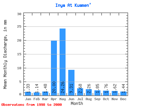
| Statistic | Jan | Feb | Mar | Apr | May | Jun | Jul | Aug | Sep | Oct | Nov | Dec | Annual |
|---|---|---|---|---|---|---|---|---|---|---|---|---|---|
| Mean | 1.33 | 1.15 | 1.48 | 20.00 | 24.26 | 9.31 | 2.68 | 2.26 | 1.85 | 1.76 | 1.62 | 1.44 | 69.08 |
| Standard Deviation | 0.10 | 0.23 | 0.10 | 6.02 | 3.13 | 3.96 | 0.51 | 0.74 | 0.15 | 0.37 | 0.30 | 0.20 | 7.10 |
| Min | 1.21 | 1.01 | 1.37 | 15.93 | 20.65 | 5.84 | 2.35 | 1.83 | 1.73 | 1.33 | 1.28 | 1.21 | 60.98 |
| Max | 1.40 | 1.42 | 1.55 | 26.91 | 26.17 | 13.61 | 3.27 | 3.11 | 2.02 | 2.01 | 1.86 | 1.58 | 74.25 |
| Coefficient of Variation | 0.08 | 0.20 | 0.07 | 0.30 | 0.13 | 0.42 | 0.19 | 0.33 | 0.08 | 0.21 | 0.19 | 0.14 | 0.10 |
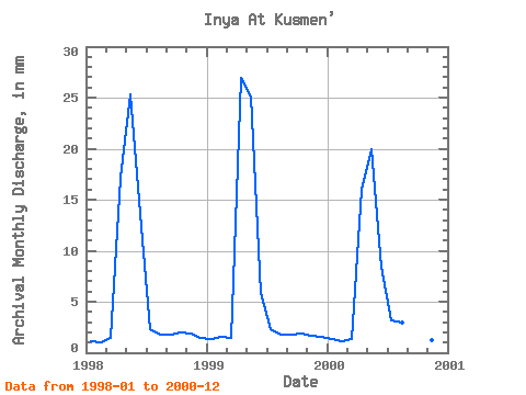
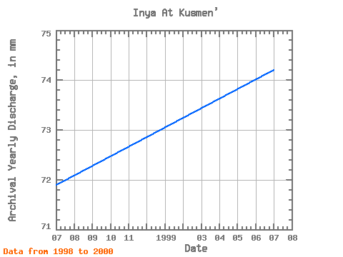
| Year | Jan | Feb | Mar | Apr | May | Jun | Jul | Aug | Sep | Oct | Nov | Dec | Annual | 1998 | 1.21 | 1.01 | 1.55 | 17.16 | 26.17 | 13.61 | 2.41 | 1.83 | 1.73 | 2.01 | 1.86 | 1.54 | 72.00 | 1999 | 1.37 | 1.42 | 1.52 | 26.91 | 25.96 | 5.84 | 2.35 | 1.84 | 1.81 | 1.95 | 1.72 | 1.58 | 74.25 | 2000 | 1.40 | 1.03 | 1.37 | 15.93 | 20.65 | 8.47 | 3.27 | 3.11 | 2.02 | 1.33 | 1.28 | 1.21 | 60.98 |
|---|
 Return to R-Arctic Net Home Page