|
|
|||||||||||||||||
| Point ID: 905 | Downloads | Plots | Site Data | Code: 07GC001 |
|
|
|||||||||||||||||
| Download | |
|---|---|
| Site Descriptor Information | Site Time Series Data |
| Link to all available data | |
|
|
| View: | Statistics | Time Series |
| Units: | m3/s |
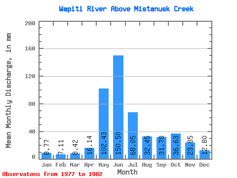
| Statistic | Jan | Feb | Mar | Apr | May | Jun | Jul | Aug | Sep | Oct | Nov | Dec | Annual |
|---|---|---|---|---|---|---|---|---|---|---|---|---|---|
| Mean | 8.76 | 7.18 | 8.42 | 16.14 | 102.41 | 150.50 | 68.04 | 32.44 | 31.78 | 36.62 | 23.85 | 12.80 | 499.29 |
| Standard Deviation | 3.84 | 4.03 | 5.43 | 6.01 | 35.82 | 57.05 | 12.42 | 11.75 | 23.04 | 21.97 | 11.69 | 4.90 | 75.02 |
| Min | 4.41 | 3.86 | 3.91 | 7.88 | 61.59 | 100.01 | 50.44 | 19.30 | 11.77 | 13.17 | 8.32 | 5.36 | 453.07 |
| Max | 14.51 | 13.62 | 16.74 | 21.60 | 159.56 | 204.12 | 79.67 | 46.53 | 60.05 | 62.49 | 42.01 | 17.96 | 611.42 |
| Coefficient of Variation | 0.44 | 0.56 | 0.65 | 0.37 | 0.35 | 0.38 | 0.18 | 0.36 | 0.72 | 0.60 | 0.49 | 0.38 | 0.15 |
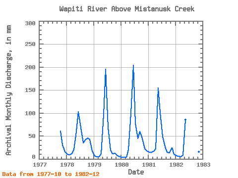
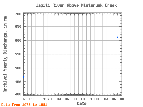
| Year | Jan | Feb | Mar | Apr | May | Jun | Jul | Aug | Sep | Oct | Nov | Dec | Annual | 1977 | 62.49 | 30.24 | 15.73 | 1978 | 10.31 | 8.58 | 11.11 | 19.87 | 61.59 | 102.38 | 70.97 | 36.60 | 41.04 | 46.75 | 42.01 | 16.96 | 467.31 | 1979 | 7.67 | 4.58 | 5.32 | 11.66 | 99.64 | 195.48 | 71.08 | 19.30 | 11.77 | 13.17 | 8.32 | 5.36 | 453.07 | 1980 | 4.41 | 3.86 | 3.91 | 19.66 | 102.66 | 204.12 | 79.67 | 46.53 | 60.05 | 46.64 | 22.57 | 17.96 | 611.42 | 1981 | 14.51 | 13.62 | 16.74 | 21.60 | 159.56 | 100.01 | 50.44 | 27.34 | 14.26 | 14.06 | 24.41 | 10.66 | 465.35 | 1982 | 6.93 | 5.23 | 5.02 | 7.88 | 88.60 | 15.55 | 10.11 |
|---|
 Return to R-Arctic Net Home Page