|
|
|||||||||||||||||
| Point ID: 9022 | Downloads | Plots | Site Data | Code: 71217 |
|
|
|||||||||||||||||
| Download | |
|---|---|
| Site Descriptor Information | Site Time Series Data |
| Link to all available data | |
|
|
| View: | Statistics | Time Series |
| Units: | m3/s |
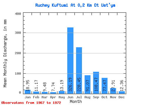
| Statistic | Jan | Feb | Mar | Apr | May | Jun | Jul | Aug | Sep | Oct | Nov | Dec | Annual |
|---|---|---|---|---|---|---|---|---|---|---|---|---|---|
| Mean | 18.95 | 11.26 | 9.48 | 7.70 | 13.18 | 326.20 | 228.41 | 91.05 | 108.47 | 77.46 | 27.91 | 12.36 | 1043.34 |
| Standard Deviation | 0.58 | 0.40 | 6.44 | 108.64 | 93.16 | 37.91 | 44.39 | ||||||
| Min | 18.95 | 11.26 | 9.06 | 7.42 | 9.06 | 195.40 | 126.07 | 65.92 | 63.80 | 77.46 | 27.91 | 12.36 | 1043.34 |
| Max | 18.95 | 11.26 | 9.89 | 7.97 | 20.60 | 441.09 | 329.60 | 147.50 | 166.69 | 77.46 | 27.91 | 12.36 | 1043.34 |
| Coefficient of Variation | 0.06 | 0.05 | 0.49 | 0.33 | 0.41 | 0.42 | 0.41 |
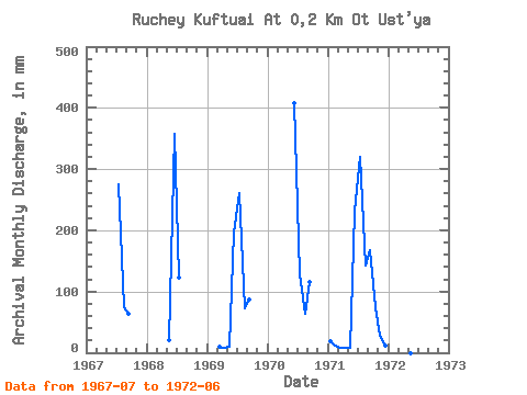
| Year | Jan | Feb | Mar | Apr | May | Jun | Jul | Aug | Sep | Oct | Nov | Dec | Annual | 1967 | 285.10 | 76.63 | 63.80 | 1968 | 20.60 | 357.30 | 126.07 | 1969 | 9.89 | 7.97 | 9.89 | 195.40 | 268.62 | 74.16 | 86.93 | 1970 | 407.54 | 132.66 | 65.92 | 116.44 | 1971 | 18.95 | 11.26 | 9.06 | 7.42 | 9.06 | 229.69 | 329.60 | 147.50 | 166.69 | 77.46 | 27.91 | 12.36 | 1043.34 | 1972 | 441.09 |
|---|
 Return to R-Arctic Net Home Page