|
|
|||||||||||||||||
| Point ID: 9008 | Downloads | Plots | Site Data | Code: 71172 |
|
|
|||||||||||||||||
| Download | |
|---|---|
| Site Descriptor Information | Site Time Series Data |
| Link to all available data | |
|
|
| View: | Statistics | Time Series |
| Units: | m3/s |
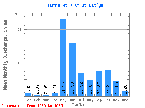
| Statistic | Jan | Feb | Mar | Apr | May | Jun | Jul | Aug | Sep | Oct | Nov | Dec | Annual |
|---|---|---|---|---|---|---|---|---|---|---|---|---|---|
| Mean | 3.85 | 2.39 | 2.05 | 3.71 | 91.88 | 63.59 | 28.52 | 19.06 | 30.27 | 32.24 | 18.66 | 6.26 | 292.47 |
| Standard Deviation | 1.37 | 1.34 | 1.48 | 3.70 | 45.55 | 38.31 | 18.58 | 18.48 | 12.67 | 3.23 | |||
| Min | 2.30 | 0.99 | 0.84 | 1.19 | 65.50 | 26.75 | 5.46 | 4.20 | 12.17 | 32.24 | 18.66 | 3.97 | 292.47 |
| Max | 4.89 | 3.67 | 3.70 | 7.96 | 144.48 | 128.11 | 55.78 | 49.30 | 40.78 | 32.24 | 18.66 | 8.55 | 292.47 |
| Coefficient of Variation | 0.35 | 0.56 | 0.72 | 1.00 | 0.50 | 0.60 | 0.65 | 0.97 | 0.42 | 0.52 |
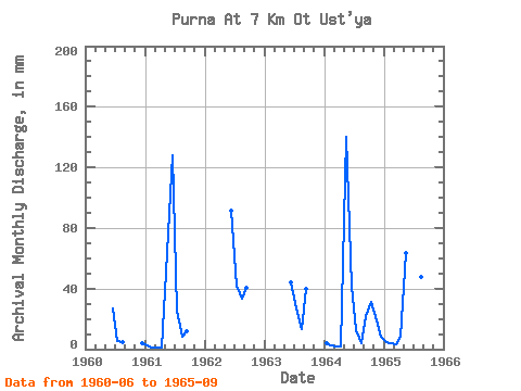
| Year | Jan | Feb | Mar | Apr | May | Jun | Jul | Aug | Sep | Oct | Nov | Dec | Annual | 1960 | 26.75 | 5.46 | 5.01 | 3.97 | 1961 | 2.30 | 0.99 | 0.84 | 1.19 | 65.67 | 128.11 | 26.27 | 8.19 | 12.17 | 1962 | 91.13 | 42.98 | 34.12 | 40.78 | 1963 | 44.08 | 27.46 | 13.58 | 39.62 | 1964 | 4.35 | 2.50 | 1.60 | 1.98 | 144.48 | 41.27 | 13.17 | 4.20 | 21.79 | 32.24 | 18.66 | 8.55 | 292.47 | 1965 | 4.89 | 3.67 | 3.70 | 7.96 | 65.50 | 50.19 | 55.78 | 49.30 | 36.98 |
|---|
 Return to R-Arctic Net Home Page