|
|
|||||||||||||||||
| Point ID: 9001 | Downloads | Plots | Site Data | Code: 71151 |
|
|
|||||||||||||||||
| Download | |
|---|---|
| Site Descriptor Information | Site Time Series Data |
| Link to all available data | |
|
|
| View: | Statistics | Time Series |
| Units: | m3/s |
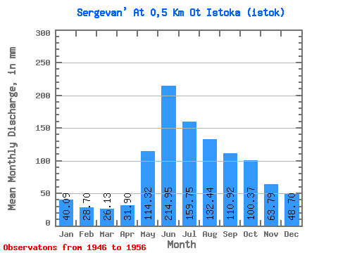
| Statistic | Jan | Feb | Mar | Apr | May | Jun | Jul | Aug | Sep | Oct | Nov | Dec | Annual |
|---|---|---|---|---|---|---|---|---|---|---|---|---|---|
| Mean | 39.93 | 28.88 | 26.13 | 31.95 | 114.31 | 214.95 | 159.58 | 132.42 | 110.92 | 100.35 | 63.79 | 48.69 | 1110.32 |
| Standard Deviation | 11.17 | 8.42 | 7.46 | 13.13 | 63.11 | 77.06 | 105.51 | 67.72 | 44.41 | 43.40 | 26.45 | 15.79 | 475.02 |
| Min | 29.10 | 18.12 | 14.55 | 12.07 | 59.38 | 137.93 | 56.41 | 89.07 | 66.09 | 56.41 | 43.10 | 35.63 | 774.42 |
| Max | 53.44 | 37.87 | 32.66 | 45.98 | 195.95 | 339.09 | 290.96 | 252.36 | 172.42 | 148.45 | 100.58 | 71.25 | 1446.21 |
| Coefficient of Variation | 0.28 | 0.29 | 0.29 | 0.41 | 0.55 | 0.36 | 0.66 | 0.51 | 0.40 | 0.43 | 0.41 | 0.32 | 0.43 |
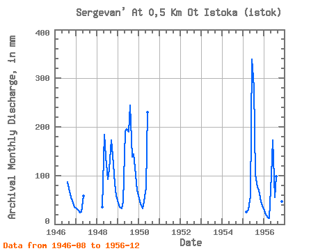
| Year | Jan | Feb | Mar | Apr | May | Jun | Jul | Aug | Sep | Oct | Nov | Dec | Annual | 1946 | 89.07 | 66.09 | 56.41 | 43.10 | 35.63 | 1947 | 32.66 | 27.05 | 24.34 | 24.43 | 59.38 | 1948 | 34.48 | 190.01 | 137.93 | 95.01 | 115.79 | 172.42 | 145.48 | 83.33 | 59.38 | 1949 | 44.53 | 32.46 | 32.66 | 45.98 | 195.95 | 195.41 | 195.95 | 252.36 | 137.93 | 148.45 | 100.58 | 71.25 | 1446.21 | 1950 | 53.44 | 37.87 | 32.66 | 45.98 | 77.19 | 229.89 | 1955 | 26.42 | 28.74 | 59.38 | 339.09 | 290.96 | 103.91 | 74.71 | 71.25 | 45.98 | 38.60 | 1956 | 29.10 | 18.12 | 14.55 | 12.07 | 103.91 | 172.42 | 56.41 | 100.94 | 103.45 | 80.16 | 45.98 | 38.60 | 774.42 |
|---|
 Return to R-Arctic Net Home Page