|
|
|||||||||||||||||
| Point ID: 8996 | Downloads | Plots | Site Data | Code: 71144 |
|
|
|||||||||||||||||
| Download | |
|---|---|
| Site Descriptor Information | Site Time Series Data |
| Link to all available data | |
|
|
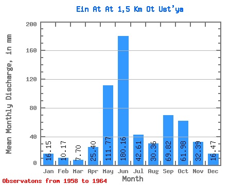
| View: | Statistics | Time Series |
| Units: | m3/s |
| Statistic | Jan | Feb | Mar | Apr | May | Jun | Jul | Aug | Sep | Oct | Nov | Dec | Annual |
|---|---|---|---|---|---|---|---|---|---|---|---|---|---|
| Mean | 16.15 | 10.26 | 7.70 | 25.40 | 111.75 | 180.16 | 42.60 | 30.36 | 69.83 | 61.96 | 32.39 | 16.47 | 578.85 |
| Standard Deviation | 1.87 | 0.38 | 1.71 | 33.48 | 90.48 | 139.96 | 21.75 | 18.15 | 53.88 | 41.39 | 16.07 | 4.97 | 204.92 |
| Min | 14.82 | 9.79 | 6.16 | 7.00 | 11.60 | 45.60 | 13.39 | 9.88 | 25.71 | 20.34 | 14.83 | 11.24 | 433.95 |
| Max | 17.47 | 10.70 | 9.88 | 75.54 | 187.60 | 405.43 | 62.01 | 50.48 | 148.31 | 103.11 | 46.37 | 21.12 | 723.75 |
| Coefficient of Variation | 0.12 | 0.04 | 0.22 | 1.32 | 0.81 | 0.78 | 0.51 | 0.60 | 0.77 | 0.67 | 0.50 | 0.30 | 0.35 |
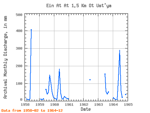
| Year | Jan | Feb | Mar | Apr | May | Jun | Jul | Aug | Sep | Oct | Nov | Dec | Annual | 1958 | 10.18 | 9.88 | 7.00 | 11.60 | 405.43 | 1959 | 9.79 | 6.52 | 11.37 | 65.77 | 39.10 | 50.48 | 148.31 | 103.11 | 46.37 | 21.12 | 1960 | 14.82 | 10.37 | 6.16 | 75.54 | 187.60 | 45.60 | 13.39 | 9.88 | 25.71 | 20.34 | 14.83 | 11.24 | 433.95 | 1962 | 121.28 | 1963 | 153.86 | 55.92 | 39.60 | 50.31 | 1964 | 17.47 | 10.70 | 8.23 | 7.69 | 136.05 | 289.00 | 62.01 | 21.48 | 54.96 | 62.44 | 35.97 | 17.04 | 723.75 |
|---|
 Return to R-Arctic Net Home Page