|
|
|||||||||||||||||
| Point ID: 8951 | Downloads | Plots | Site Data | Code: 71028 |
|
|
|||||||||||||||||
| Download | |
|---|---|
| Site Descriptor Information | Site Time Series Data |
| Link to all available data | |
|
|
| View: | Statistics | Time Series |
| Units: | m3/s |
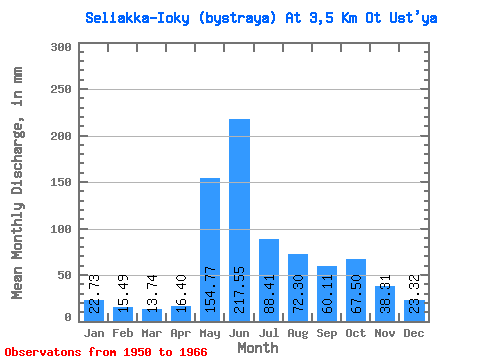
| Statistic | Jan | Feb | Mar | Apr | May | Jun | Jul | Aug | Sep | Oct | Nov | Dec | Annual |
|---|---|---|---|---|---|---|---|---|---|---|---|---|---|
| Mean | 22.73 | 15.61 | 13.72 | 16.42 | 154.75 | 217.55 | 88.39 | 72.29 | 60.11 | 67.51 | 38.30 | 23.31 | 771.48 |
| Standard Deviation | 10.64 | 7.28 | 5.43 | 7.97 | 89.72 | 58.34 | 43.81 | 28.07 | 19.50 | 24.18 | 15.57 | 9.75 | 117.02 |
| Min | 9.39 | 7.20 | 7.91 | 5.74 | 38.05 | 110.47 | 28.16 | 20.75 | 29.17 | 30.14 | 8.13 | 6.42 | 527.94 |
| Max | 37.06 | 24.76 | 22.73 | 32.04 | 339.94 | 300.33 | 174.42 | 112.16 | 90.86 | 114.14 | 58.82 | 37.55 | 940.39 |
| Coefficient of Variation | 0.47 | 0.47 | 0.40 | 0.48 | 0.58 | 0.27 | 0.50 | 0.39 | 0.32 | 0.36 | 0.41 | 0.42 | 0.15 |
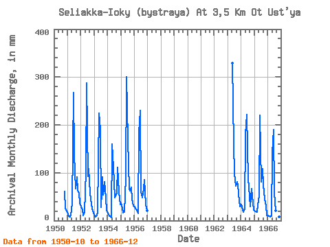
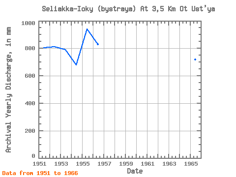
| Year | Jan | Feb | Mar | Apr | May | Jun | Jul | Aug | Sep | Oct | Nov | Dec | Annual | 1950 | 63.24 | 24.39 | 21.25 | 1951 | 13.34 | 8.55 | 7.91 | 10.04 | 38.05 | 267.33 | 142.79 | 68.19 | 90.86 | 64.23 | 56.43 | 37.55 | 805.50 | 1952 | 30.63 | 21.16 | 10.38 | 16.26 | 107.71 | 286.94 | 94.87 | 112.16 | 56.91 | 35.08 | 24.39 | 17.29 | 813.75 | 1953 | 9.39 | 7.20 | 10.87 | 17.69 | 231.24 | 190.34 | 28.16 | 93.38 | 53.56 | 84.00 | 47.82 | 21.74 | 791.91 | 1954 | 16.80 | 9.00 | 9.39 | 5.74 | 164.53 | 110.47 | 48.91 | 54.35 | 56.91 | 114.14 | 58.82 | 35.08 | 680.31 | 1955 | 37.06 | 24.76 | 17.29 | 18.17 | 91.90 | 300.33 | 174.42 | 67.20 | 61.69 | 71.64 | 44.48 | 32.12 | 940.39 | 1956 | 30.63 | 22.96 | 22.73 | 15.30 | 188.75 | 230.03 | 62.26 | 49.41 | 66.00 | 87.45 | 33.48 | 20.75 | 828.30 | 1963 | 339.94 | 159.73 | 100.80 | 74.11 | 80.34 | 76.58 | 41.13 | 30.63 | 1964 | 34.59 | 21.16 | 18.78 | 23.43 | 186.27 | 220.94 | 88.94 | 72.14 | 29.17 | 69.17 | 51.17 | 22.23 | 835.58 | 1965 | 20.75 | 17.56 | 17.79 | 32.04 | 53.86 | 219.51 | 83.01 | 111.17 | 74.12 | 46.94 | 31.09 | 11.36 | 719.61 | 1966 | 11.36 | 8.10 | 8.40 | 9.09 | 145.26 | 189.86 | 59.79 | 20.75 | 31.56 | 30.14 | 8.13 | 6.42 | 527.94 |
|---|
 Return to R-Arctic Net Home Page