|
|
|||||||||||||||||
| Point ID: 895 | Downloads | Plots | Site Data | Code: 07FC006 |
|
|
|||||||||||||||||
| Download | |
|---|---|
| Site Descriptor Information | Site Time Series Data |
| Link to all available data | |
|
|
| View: | Statistics | Time Series |
| Units: | m3/s |
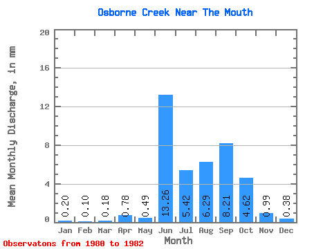
| Statistic | Jan | Feb | Mar | Apr | May | Jun | Jul | Aug | Sep | Oct | Nov | Dec | Annual |
|---|---|---|---|---|---|---|---|---|---|---|---|---|---|
| Mean | 0.21 | 0.10 | 0.18 | 0.77 | 0.49 | 13.26 | 5.42 | 6.29 | 8.21 | 4.62 | 1.00 | 0.39 | 41.84 |
| Standard Deviation | 0.36 | 0.16 | 0.25 | 1.05 | 1.29 | 0.56 | |||||||
| Min | 0.00 | 0.00 | 0.00 | 0.02 | 0.49 | 13.26 | 5.42 | 6.29 | 8.21 | 4.62 | 0.00 | 0.00 | 41.84 |
| Max | 0.62 | 0.28 | 0.47 | 1.51 | 0.49 | 13.26 | 5.42 | 6.29 | 8.21 | 4.62 | 2.46 | 1.03 | 41.84 |
| Coefficient of Variation | 1.73 | 1.56 | 1.42 | 1.37 | 1.29 | 1.44 |
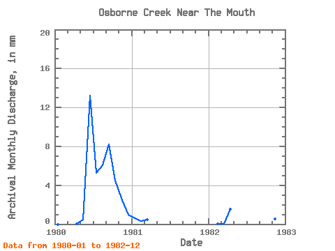
| Year | Jan | Feb | Mar | Apr | May | Jun | Jul | Aug | Sep | Oct | Nov | Dec | Annual | 1980 | 0.00 | 0.00 | 0.00 | 0.02 | 0.49 | 13.26 | 5.42 | 6.29 | 8.21 | 4.62 | 2.46 | 1.03 | 41.84 | 1981 | 0.62 | 0.28 | 0.47 | 0.00 | 0.00 | 1982 | 0.00 | 0.02 | 0.07 | 1.51 | 0.54 | 0.13 |
|---|
 Return to R-Arctic Net Home Page