|
|
|||||||||||||||||
| Point ID: 8937 | Downloads | Plots | Site Data | Code: 70609 |
|
|
|||||||||||||||||
| Download | |
|---|---|
| Site Descriptor Information | Site Time Series Data |
| Link to all available data | |
|
|
| View: | Statistics | Time Series |
| Units: | m3/s |
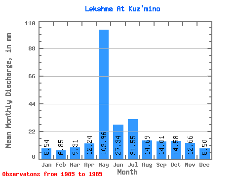
| Statistic | Jan | Feb | Mar | Apr | May | Jun | Jul | Aug | Sep | Oct | Nov | Dec | Annual |
|---|---|---|---|---|---|---|---|---|---|---|---|---|---|
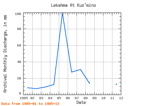
| Mean | 8.54 | 6.91 | 9.31 | 12.23 | 102.94 | 27.34 | 31.54 | 14.69 | 14.01 | 14.58 | 12.66 | 8.50 | 261.35 |
| Standard Deviation | |||||||||||||
| Min | 8.54 | 6.91 | 9.31 | 12.23 | 102.94 | 27.34 | 31.54 | 14.69 | 14.01 | 14.58 | 12.66 | 8.50 | 261.35 |
| Max | 8.54 | 6.91 | 9.31 | 12.23 | 102.94 | 27.34 | 31.54 | 14.69 | 14.01 | 14.58 | 12.66 | 8.50 | 261.35 |
| Coefficient of Variation |
| Year | Jan | Feb | Mar | Apr | May | Jun | Jul | Aug | Sep | Oct | Nov | Dec | Annual | 1985 | 8.54 | 6.91 | 9.31 | 12.23 | 102.94 | 27.34 | 31.54 | 14.69 | 14.01 | 14.58 | 12.66 | 8.50 | 261.35 |
|---|
 Return to R-Arctic Net Home Page