|
|
|||||||||||||||||
| Point ID: 8936 | Downloads | Plots | Site Data | Code: 70608 |
|
|
|||||||||||||||||
| Download | |
|---|---|
| Site Descriptor Information | Site Time Series Data |
| Link to all available data | |
|
|
| View: | Statistics | Time Series |
| Units: | m3/s |
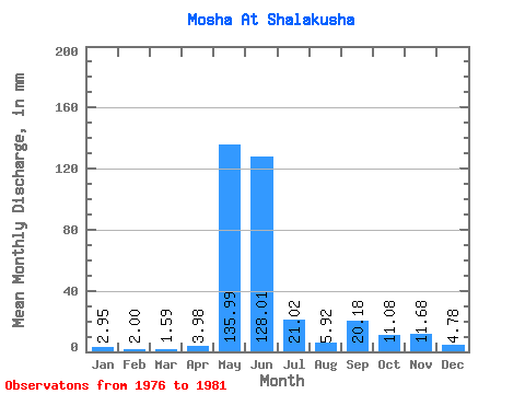
| Statistic | Jan | Feb | Mar | Apr | May | Jun | Jul | Aug | Sep | Oct | Nov | Dec | Annual |
|---|---|---|---|---|---|---|---|---|---|---|---|---|---|
| Mean | 2.95 | 2.01 | 1.59 | 3.98 | 135.97 | 128.01 | 21.02 | 5.91 | 20.18 | 11.08 | 11.68 | 4.78 | 266.12 |
| Standard Deviation | 2.63 | 2.08 | 1.65 | 4.05 | 95.32 | 101.36 | 18.76 | 2.84 | 17.58 | 3.22 | 13.12 | 3.85 | |
| Min | 0.84 | 0.47 | 0.34 | 0.38 | 1.57 | 40.28 | 6.88 | 3.72 | 4.55 | 6.26 | 3.96 | 1.73 | 266.12 |
| Max | 5.89 | 5.09 | 4.48 | 10.11 | 206.79 | 245.19 | 48.34 | 10.08 | 41.38 | 12.98 | 26.82 | 9.10 | 266.12 |
| Coefficient of Variation | 0.89 | 1.04 | 1.04 | 1.02 | 0.70 | 0.79 | 0.89 | 0.48 | 0.87 | 0.29 | 1.12 | 0.81 |
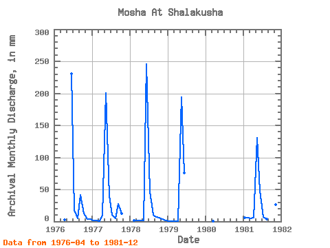
| Year | Jan | Feb | Mar | Apr | May | Jun | Jul | Aug | Sep | Oct | Nov | Dec | Annual | 1976 | 2.28 | 230.68 | 17.78 | 4.98 | 41.38 | 12.98 | 4.25 | 3.51 | 1977 | 2.11 | 1.12 | 0.95 | 10.11 | 206.79 | 40.28 | 11.06 | 4.88 | 27.82 | 12.72 | 1978 | 1.37 | 1.18 | 1.12 | 1.57 | 245.19 | 48.34 | 10.08 | 6.96 | 6.26 | 3.96 | 1.73 | 1979 | 0.84 | 0.47 | 0.34 | 0.38 | 200.59 | 76.06 | 1980 | 0.99 | 1981 | 5.89 | 5.09 | 4.48 | 6.00 | 134.93 | 47.84 | 6.88 | 3.72 | 4.55 | 12.36 | 26.82 | 9.10 | 266.12 |
|---|
 Return to R-Arctic Net Home Page