|
|
|||||||||||||||||
| Point ID: 8927 | Downloads | Plots | Site Data | Code: 70594 |
|
|
|||||||||||||||||
| Download | |
|---|---|
| Site Descriptor Information | Site Time Series Data |
| Link to all available data | |
|
|
| View: | Statistics | Time Series |
| Units: | m3/s |
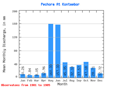
| Statistic | Jan | Feb | Mar | Apr | May | Jun | Jul | Aug | Sep | Oct | Nov | Dec | Annual |
|---|---|---|---|---|---|---|---|---|---|---|---|---|---|
| Mean | 10.26 | 7.91 | 8.04 | 12.96 | 160.31 | 157.33 | 45.34 | 32.10 | 37.57 | 47.17 | 28.71 | 12.72 | 599.79 |
| Standard Deviation | 1.96 | 0.92 | 0.67 | 9.99 | 60.40 | 60.68 | 14.99 | 12.83 | 15.40 | 24.39 | 0.20 | 1.99 | 162.72 |
| Min | 8.50 | 7.00 | 7.19 | 7.11 | 92.14 | 69.24 | 32.55 | 20.26 | 19.43 | 29.93 | 28.57 | 11.31 | 484.73 |
| Max | 13.41 | 9.11 | 9.03 | 30.60 | 213.87 | 211.35 | 69.67 | 46.44 | 56.55 | 64.42 | 28.86 | 14.12 | 714.85 |
| Coefficient of Variation | 0.19 | 0.12 | 0.08 | 0.77 | 0.38 | 0.39 | 0.33 | 0.40 | 0.41 | 0.52 | 0.01 | 0.16 | 0.27 |
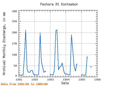
| Year | Jan | Feb | Mar | Apr | May | Jun | Jul | Aug | Sep | Oct | Nov | Dec | Annual | 1981 | 8.50 | 7.00 | 8.09 | 7.39 | 97.01 | 210.62 | 34.61 | 21.61 | 19.43 | 29.93 | 28.57 | 11.31 | 484.73 | 1982 | 9.18 | 7.78 | 7.75 | 11.17 | 203.38 | 69.24 | 41.20 | 20.26 | 25.23 | 1983 | 10.82 | 8.57 | 8.16 | 30.60 | 213.87 | 211.35 | 32.55 | 45.32 | 47.85 | 64.42 | 28.86 | 14.12 | 714.85 | 1984 | 13.41 | 9.11 | 9.03 | 8.55 | 195.14 | 125.07 | 48.69 | 26.86 | 56.55 | 1985 | 9.36 | 7.10 | 7.19 | 7.11 | 92.14 | 170.38 | 69.67 | 46.44 | 38.79 |
|---|
 Return to R-Arctic Net Home Page