|
|
|||||||||||||||||
| Point ID: 8902 | Downloads | Plots | Site Data | Code: 70561 |
|
|
|||||||||||||||||
| Download | |
|---|---|
| Site Descriptor Information | Site Time Series Data |
| Link to all available data | |
|
|
| View: | Statistics | Time Series |
| Units: | m3/s |
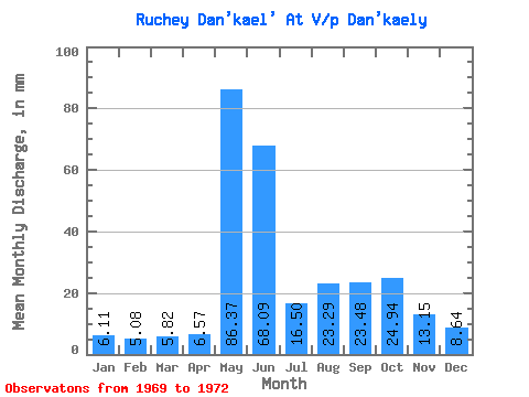
| Statistic | Jan | Feb | Mar | Apr | May | Jun | Jul | Aug | Sep | Oct | Nov | Dec | Annual |
|---|---|---|---|---|---|---|---|---|---|---|---|---|---|
| Mean | 6.12 | 5.09 | 5.78 | 6.53 | 86.36 | 68.09 | 16.50 | 23.29 | 23.48 | 24.92 | 13.17 | 8.67 | 284.35 |
| Standard Deviation | 1.12 | 0.93 | 0.63 | 3.52 | 31.56 | 49.80 | 6.06 | 16.47 | 15.94 | 4.99 | 1.66 | 0.79 | 40.24 |
| Min | 5.14 | 4.42 | 5.05 | 4.04 | 64.04 | 32.87 | 11.64 | 11.64 | 12.21 | 19.41 | 12.21 | 7.76 | 255.89 |
| Max | 7.33 | 6.15 | 6.17 | 9.02 | 108.67 | 103.30 | 23.29 | 34.93 | 34.75 | 29.11 | 15.08 | 9.22 | 312.80 |
| Coefficient of Variation | 0.18 | 0.18 | 0.11 | 0.54 | 0.36 | 0.73 | 0.37 | 0.71 | 0.68 | 0.20 | 0.13 | 0.09 | 0.14 |
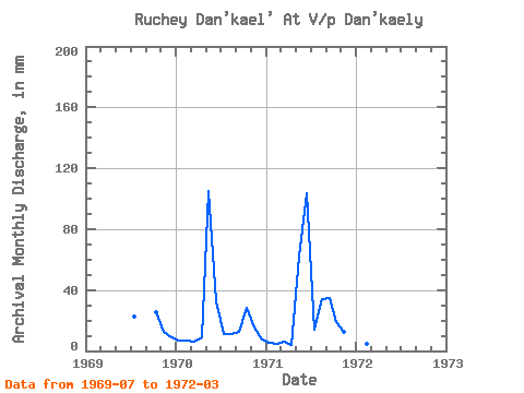
| Year | Jan | Feb | Mar | Apr | May | Jun | Jul | Aug | Sep | Oct | Nov | Dec | Annual | 1969 | 23.29 | 26.26 | 12.21 | 9.22 | 1970 | 7.33 | 6.15 | 6.17 | 9.02 | 108.67 | 32.87 | 11.64 | 11.64 | 12.21 | 29.11 | 15.08 | 7.76 | 255.89 | 1971 | 5.88 | 4.69 | 6.11 | 4.04 | 64.04 | 103.30 | 14.55 | 34.93 | 34.75 | 19.41 | 12.21 | 9.02 | 312.80 | 1972 | 5.14 | 4.42 | 5.05 |
|---|
 Return to R-Arctic Net Home Page