|
|
|||||||||||||||||
| Point ID: 8897 | Downloads | Plots | Site Data | Code: 70555 |
|
|
|||||||||||||||||
| Download | |
|---|---|
| Site Descriptor Information | Site Time Series Data |
| Link to all available data | |
|
|
| View: | Statistics | Time Series |
| Units: | m3/s |
| Statistic | Jan | Feb | Mar | Apr | May | Jun | Jul | Aug | Sep | Oct | Nov | Dec | Annual |
|---|---|---|---|---|---|---|---|---|---|---|---|---|---|
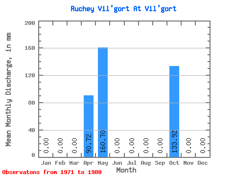
| Mean | 0.00 | 0.00 | 0.00 | 88.34 | 161.64 | 1.11 | 0.96 | 0.67 | 1.30 | 135.51 | 0.00 | 0.00 | 265.37 |
| Standard Deviation | 0.00 | 0.00 | 0.00 | 57.16 | 346.04 | 1.90 | 2.53 | 1.64 | 2.01 | 298.52 | 0.00 | 0.00 | 357.25 |
| Min | 0.00 | 0.00 | 0.00 | 3.89 | 0.00 | 0.00 | 0.00 | 0.00 | 0.00 | 0.00 | 0.00 | 0.00 | 39.45 |
| Max | 0.00 | 0.00 | 0.00 | 142.56 | 941.32 | 3.89 | 6.70 | 4.02 | 3.89 | 669.50 | 0.00 | 0.00 | 898.14 |
| Coefficient of Variation | 0.65 | 2.14 | 1.71 | 2.65 | 2.45 | 1.55 | 2.20 | 1.35 |
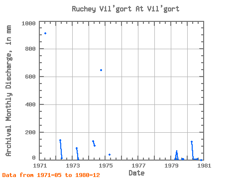
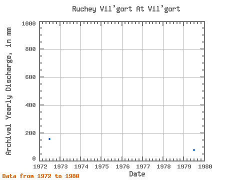
| Year | Jan | Feb | Mar | Apr | May | Jun | Jul | Aug | Sep | Oct | Nov | Dec | Annual | 1971 | 941.32 | 0.00 | 0.00 | 0.00 | 0.00 | 1972 | 0.00 | 0.00 | 0.00 | 142.56 | 13.39 | 0.00 | 0.00 | 0.00 | 0.00 | 0.00 | 0.00 | 0.00 | 157.80 | 1973 | 0.00 | 0.00 | 0.00 | 81.65 | 4.02 | 0.00 | 0.00 | 0.00 | 0.00 | 1974 | 0.00 | 0.00 | 0.00 | 136.08 | 104.44 | 0.00 | 0.00 | 0.00 | 0.00 | 669.50 | 0.00 | 0.00 | 898.14 | 1975 | 0.00 | 0.00 | 0.00 | 38.88 | 0.00 | 0.00 | 0.00 | 0.00 | 0.00 | 0.00 | 0.00 | 0.00 | 39.45 | 1979 | 0.00 | 0.00 | 0.00 | 3.89 | 64.27 | 3.89 | 0.00 | 0.00 | 3.89 | 4.02 | 0.00 | 0.00 | 78.90 | 1980 | 0.00 | 0.00 | 0.00 | 127.01 | 4.02 | 3.89 | 6.70 | 4.02 | 3.89 | 4.02 | 0.00 | 0.00 | 152.54 |
|---|
 Return to R-Arctic Net Home Page