|
|
|||||||||||||||||
| Point ID: 889 | Downloads | Plots | Site Data | Code: 07FB010 |
|
|
|||||||||||||||||
| Download | |
|---|---|
| Site Descriptor Information | Site Time Series Data |
| Link to all available data | |
|
|
| View: | Statistics | Time Series |
| Units: | m3/s |
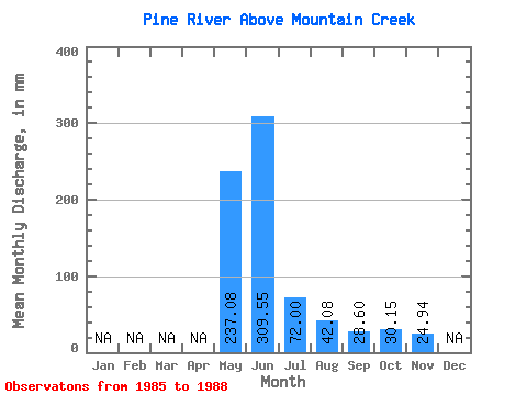
| Statistic | Jan | Feb | Mar | Apr | May | Jun | Jul | Aug | Sep | Oct | Nov | Dec | Annual |
|---|---|---|---|---|---|---|---|---|---|---|---|---|---|
| Mean | 237.04 | 309.55 | 71.99 | 42.07 | 28.60 | 30.14 | 24.94 | ||||||
| Standard Deviation | 63.80 | 86.98 | 27.21 | 31.93 | 11.75 | 7.37 | 2.79 | ||||||
| Min | 178.01 | 203.68 | 47.07 | 19.70 | 20.18 | 21.72 | 22.97 | ||||||
| Max | 307.36 | 398.18 | 96.52 | 89.40 | 45.94 | 35.36 | 26.91 | ||||||
| Coefficient of Variation | 0.27 | 0.28 | 0.38 | 0.76 | 0.41 | 0.24 | 0.11 |
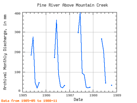
| Year | Jan | Feb | Mar | Apr | May | Jun | Jul | Aug | Sep | Oct | Nov | Dec | Annual | 1985 | 188.29 | 276.43 | 49.84 | 19.70 | 45.94 | 1986 | 178.01 | 359.89 | 94.54 | 27.69 | 20.18 | 33.35 | 1987 | 307.36 | 398.18 | 96.52 | 89.40 | 22.97 | 21.72 | 22.97 | 1988 | 274.52 | 203.68 | 47.07 | 31.49 | 25.31 | 35.36 | 26.91 |
|---|
 Return to R-Arctic Net Home Page