|
|
|||||||||||||||||
| Point ID: 8844 | Downloads | Plots | Site Data | Code: 70127 |
|
|
|||||||||||||||||
| Download | |
|---|---|
| Site Descriptor Information | Site Time Series Data |
| Link to all available data | |
|
|
| View: | Statistics | Time Series |
| Units: | m3/s |
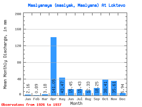
| Statistic | Jan | Feb | Mar | Apr | May | Jun | Jul | Aug | Sep | Oct | Nov | Dec | Annual |
|---|---|---|---|---|---|---|---|---|---|---|---|---|---|
| Mean | 2.16 | 0.89 | 3.19 | 141.06 | 43.46 | 15.45 | 15.43 | 12.32 | 18.25 | 38.41 | 35.62 | 5.94 | 328.86 |
| Standard Deviation | 1.75 | 0.75 | 5.67 | 56.91 | 48.87 | 14.08 | 20.99 | 19.24 | 20.92 | 29.17 | 19.55 | 7.69 | 98.14 |
| Min | 0.42 | 0.13 | 0.09 | 0.67 | 4.10 | 0.66 | 0.27 | 0.14 | 0.13 | 12.71 | 10.06 | 0.72 | 242.10 |
| Max | 6.29 | 2.00 | 18.59 | 206.30 | 183.09 | 46.15 | 58.07 | 50.28 | 50.52 | 107.67 | 76.84 | 28.43 | 520.79 |
| Coefficient of Variation | 0.81 | 0.84 | 1.78 | 0.40 | 1.12 | 0.91 | 1.36 | 1.56 | 1.15 | 0.76 | 0.55 | 1.29 | 0.30 |
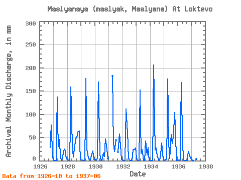
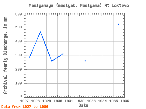
| Year | Jan | Feb | Mar | Apr | May | Jun | Jul | Aug | Sep | Oct | Nov | Dec | Annual | 1926 | 28.97 | 76.84 | 6.98 | 1927 | 0.42 | 0.13 | 0.42 | 137.53 | 31.29 | 46.15 | 4.65 | 1.09 | 9.79 | 25.82 | 20.50 | 5.20 | 284.90 | 1928 | 2.60 | 1.62 | 0.09 | 158.69 | 37.71 | 7.54 | 25.28 | 50.28 | 48.93 | 64.35 | 64.01 | 3.55 | 465.59 | 1929 | 1.92 | 1.13 | 0.69 | 0.67 | 183.09 | 23.80 | 6.97 | 1.23 | 1.85 | 14.76 | 20.77 | 3.01 | 256.88 | 1930 | 3.14 | 1.88 | 4.78 | 169.27 | 13.53 | 0.66 | 0.96 | 17.63 | 9.26 | 47.82 | 32.94 | 5.06 | 308.51 | 1931 | 182.50 | 38.12 | 19.70 | 46.32 | 18.38 | 59.44 | 33.99 | 3.29 | 1932 | 1.13 | 0.37 | 0.24 | 110.83 | 62.85 | 5.16 | 0.33 | 0.23 | 0.18 | 25.41 | 24.47 | 28.43 | 259.61 | 1933 | 6.29 | 0.21 | 0.34 | 152.08 | 16.26 | 24.20 | 0.55 | 0.41 | 42.45 | 12.71 | 28.97 | 0.72 | 288.16 | 1934 | 0.62 | 0.33 | 0.98 | 206.30 | 24.32 | 27.51 | 10.93 | 1.37 | 1.06 | 14.62 | 38.62 | 3.56 | 333.24 | 1935 | 0.64 | 1.13 | 4.38 | 175.89 | 38.12 | 4.89 | 58.07 | 38.53 | 50.52 | 107.67 | 40.61 | 0.73 | 520.79 | 1936 | 1.92 | 2.00 | 1.37 | 167.95 | 28.69 | 2.12 | 0.27 | 0.14 | 0.13 | 20.91 | 10.06 | 4.79 | 242.10 | 1937 | 2.88 | 0.13 | 18.59 | 89.93 | 4.10 | 8.20 |
|---|
 Return to R-Arctic Net Home Page