|
|
|||||||||||||||||
| Point ID: 8842 | Downloads | Plots | Site Data | Code: 70119 |
|
|
|||||||||||||||||
| Download | |
|---|---|
| Site Descriptor Information | Site Time Series Data |
| Link to all available data | |
|
|
| View: | Statistics | Time Series |
| Units: | m3/s |
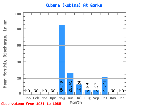
| Statistic | Jan | Feb | Mar | Apr | May | Jun | Jul | Aug | Sep | Oct | Nov | Dec | Annual |
|---|---|---|---|---|---|---|---|---|---|---|---|---|---|
| Mean | 85.17 | 26.45 | 12.23 | 5.59 | 5.27 | 21.21 | |||||||
| Standard Deviation | 20.06 | 6.29 | 12.93 | 5.07 | 2.52 | 14.42 | |||||||
| Min | 64.06 | 16.36 | 4.75 | 2.68 | 2.74 | 11.26 | |||||||
| Max | 108.69 | 32.78 | 35.18 | 14.60 | 8.82 | 46.21 | |||||||
| Coefficient of Variation | 0.24 | 0.24 | 1.06 | 0.91 | 0.48 | 0.68 |
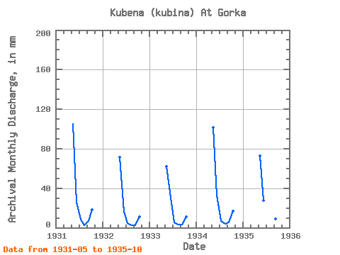
| Year | Jan | Feb | Mar | Apr | May | Jun | Jul | Aug | Sep | Oct | Nov | Dec | Annual | 1931 | 108.69 | 25.41 | 8.82 | 2.91 | 6.63 | 19.17 | 1932 | 73.51 | 16.36 | 4.75 | 2.68 | 2.74 | 11.26 | 1933 | 64.06 | 30.24 | 5.33 | 3.68 | 3.13 | 11.63 | 1934 | 104.50 | 32.78 | 7.09 | 4.10 | 5.03 | 17.77 | 1935 | 75.09 | 27.45 | 35.18 | 14.60 | 8.82 | 46.21 |
|---|
 Return to R-Arctic Net Home Page