|
|
|||||||||||||||||
| Point ID: 8817 | Downloads | Plots | Site Data | Code: 12386 |
|
|
|||||||||||||||||
| Download | |
|---|---|
| Site Descriptor Information | Site Time Series Data |
| Link to all available data | |

|

|
| View: | Statistics | Time Series |
| Units: | m3/s |
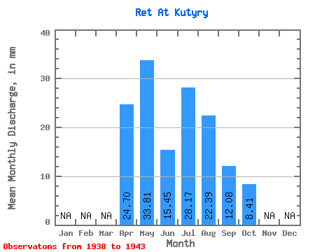
| Statistic | Jan | Feb | Mar | Apr | May | Jun | Jul | Aug | Sep | Oct | Nov | Dec | Annual |
|---|---|---|---|---|---|---|---|---|---|---|---|---|---|
| Mean | 24.70 | 33.80 | 15.45 | 28.16 | 22.38 | 12.09 | 8.41 | ||||||
| Standard Deviation | 30.56 | 13.09 | 42.23 | 41.66 | 19.57 | 8.36 | |||||||
| Min | 24.70 | 0.48 | 2.64 | 0.63 | 0.86 | 1.27 | 0.56 | ||||||
| Max | 24.70 | 82.36 | 33.74 | 101.06 | 107.12 | 51.59 | 18.70 | ||||||
| Coefficient of Variation | 0.90 | 0.85 | 1.50 | 1.86 | 1.62 | 0.99 |
| Year | Jan | Feb | Mar | Apr | May | Jun | Jul | Aug | Sep | Oct | Nov | Dec | Annual | 1938 | 3.79 | 6.85 | 1939 | 38.15 | 12.71 | 1.72 | 3.54 | 1.83 | 2.78 | 1940 | 82.36 | 33.74 | 9.10 | 10.11 | 2.44 | 0.56 | 1941 | 18.72 | 2.64 | 0.63 | 0.86 | 1.27 | 1942 | 29.31 | 12.71 | 28.30 | 8.84 | 8.56 | 18.70 | 1943 | 24.70 | 0.48 | 101.06 | 107.12 | 51.59 | 11.62 |
|---|
 Return to R-Arctic Net Home Page