|
|
|||||||||||||||||
| Point ID: 8806 | Downloads | Plots | Site Data | Code: 12293 |
|
|
|||||||||||||||||
| Download | |
|---|---|
| Site Descriptor Information | Site Time Series Data |
| Link to all available data | |
|
|
| View: | Statistics | Time Series |
| Units: | m3/s |
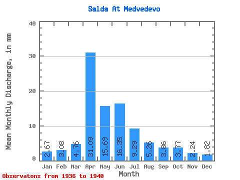
| Statistic | Jan | Feb | Mar | Apr | May | Jun | Jul | Aug | Sep | Oct | Nov | Dec | Annual |
|---|---|---|---|---|---|---|---|---|---|---|---|---|---|
| Mean | 2.67 | 3.11 | 4.76 | 31.09 | 15.69 | 16.36 | 9.29 | 5.26 | 3.86 | 3.77 | 2.24 | 1.82 | 99.94 |
| Standard Deviation | 0.52 | 0.83 | 0.77 | 6.94 | 6.10 | 19.99 | 6.55 | 2.71 | 1.45 | 0.84 | 0.30 | 0.51 | 32.99 |
| Min | 2.02 | 2.40 | 3.87 | 20.98 | 7.19 | 5.51 | 4.14 | 3.48 | 2.61 | 2.47 | 1.81 | 1.39 | 76.20 |
| Max | 3.33 | 4.50 | 5.96 | 35.64 | 21.04 | 46.29 | 19.45 | 9.98 | 6.11 | 4.72 | 2.50 | 2.55 | 148.16 |
| Coefficient of Variation | 0.20 | 0.27 | 0.16 | 0.22 | 0.39 | 1.22 | 0.70 | 0.52 | 0.37 | 0.22 | 0.14 | 0.28 | 0.33 |
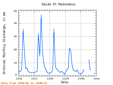
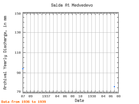
| Year | Jan | Feb | Mar | Apr | May | Jun | Jul | Aug | Sep | Oct | Nov | Dec | Annual | 1936 | 3.33 | 3.19 | 4.83 | 35.64 | 21.04 | 5.51 | 6.38 | 3.48 | 2.79 | 2.47 | 2.50 | 2.55 | 93.86 | 1937 | 2.82 | 2.83 | 3.87 | 32.09 | 15.54 | 46.29 | 19.45 | 9.98 | 6.11 | 4.21 | 2.36 | 2.15 | 148.16 | 1938 | 2.27 | 2.61 | 4.69 | 35.64 | 7.19 | 5.52 | 4.14 | 3.67 | 2.61 | 3.59 | 2.48 | 1.39 | 76.20 | 1939 | 2.90 | 4.50 | 5.96 | 20.98 | 18.97 | 8.10 | 4.30 | 4.05 | 3.36 | 4.72 | 2.04 | 1.56 | 81.55 | 1940 | 2.02 | 2.40 | 4.45 | 12.20 | 5.15 | 4.44 | 3.86 | 1.81 | 1.45 |
|---|
 Return to R-Arctic Net Home Page