|
|
|||||||||||||||||
| Point ID: 8791 | Downloads | Plots | Site Data | Code: 12226 |
|
|
|||||||||||||||||
| Download | |
|---|---|
| Site Descriptor Information | Site Time Series Data |
| Link to all available data | |
|
|
| View: | Statistics | Time Series |
| Units: | m3/s |
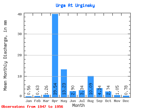
| Statistic | Jan | Feb | Mar | Apr | May | Jun | Jul | Aug | Sep | Oct | Nov | Dec | Annual |
|---|---|---|---|---|---|---|---|---|---|---|---|---|---|
| Mean | 0.56 | 0.63 | 1.26 | 39.55 | 13.23 | 2.90 | 3.34 | 10.09 | 4.34 | 2.74 | 1.05 | 0.78 | 27.63 |
| Standard Deviation | 0.50 | 0.42 | 1.30 | 45.12 | 24.07 | 1.99 | 3.74 | 25.01 | 5.43 | 3.00 | 0.60 | 0.47 | 0.66 |
| Min | 0.00 | 0.20 | 0.30 | 12.00 | 1.67 | 1.15 | 0.06 | 0.00 | 1.00 | 0.56 | 0.00 | 0.00 | 26.85 |
| Max | 1.35 | 1.16 | 3.50 | 123.06 | 81.06 | 7.39 | 11.76 | 81.06 | 17.69 | 10.18 | 1.85 | 1.19 | 28.23 |
| Coefficient of Variation | 0.90 | 0.67 | 1.03 | 1.14 | 1.82 | 0.69 | 1.12 | 2.48 | 1.25 | 1.09 | 0.57 | 0.60 | 0.02 |
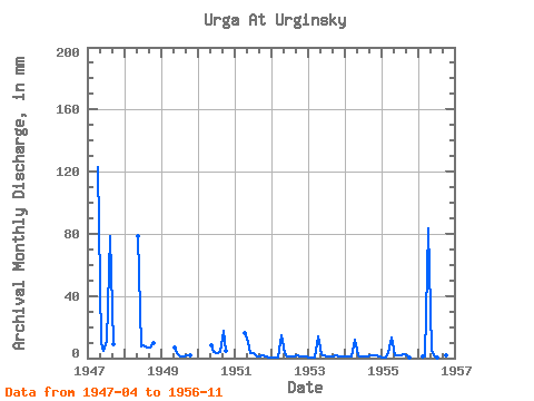
| Year | Jan | Feb | Mar | Apr | May | Jun | Jul | Aug | Sep | Oct | Nov | Dec | Annual | 1947 | 123.06 | 10.25 | 4.92 | 11.76 | 81.06 | 8.77 | 1948 | 81.06 | 7.39 | 8.27 | 6.76 | 7.00 | 10.18 | 1949 | 6.75 | 2.92 | 1.27 | 1.19 | 1.46 | 1.51 | 1950 | 8.74 | 3.62 | 3.42 | 3.97 | 17.69 | 4.53 | 1951 | 16.00 | 10.81 | 3.00 | 3.02 | 1.19 | 1.15 | 1.59 | 1.23 | 0.71 | 1952 | 0.48 | 0.38 | 0.43 | 14.54 | 3.26 | 1.38 | 1.35 | 1.43 | 1.46 | 1.27 | 1.08 | 1.03 | 28.23 | 1953 | 0.60 | 0.41 | 0.30 | 13.92 | 2.54 | 1.54 | 1.43 | 1.19 | 1.31 | 1.83 | 0.92 | 1.19 | 27.32 | 1954 | 1.35 | 1.01 | 0.95 | 12.00 | 1.67 | 1.15 | 1.11 | 1.27 | 1.69 | 1.67 | 1.85 | 0.95 | 26.85 | 1955 | 0.34 | 0.20 | 3.50 | 13.46 | 2.23 | 1.47 | 1.68 | 2.79 | 1.85 | 0.56 | 0.00 | 0.00 | 28.12 | 1956 | 0.00 | 1.16 | 1.11 | 83.84 | 5.01 | 1.61 | 0.06 | 0.00 | 1.00 | 1.51 | 1.23 |
|---|
 Return to R-Arctic Net Home Page