|
|
|||||||||||||||||
| Point ID: 873 | Downloads | Plots | Site Data | Code: 07EE011 |
|
|
|||||||||||||||||
| Download | |
|---|---|
| Site Descriptor Information | Site Time Series Data |
| Link to all available data | |
|
|
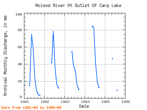
| View: | Statistics | Time Series |
| Units: | m3/s |
| Statistic | Jan | Feb | Mar | Apr | May | Jun | Jul | Aug | Sep | Oct | Nov | Dec | Annual |
|---|---|---|---|---|---|---|---|---|---|---|---|---|---|
| Mean | 14.26 | 62.44 | 61.48 | 31.10 | 14.46 | 9.10 | 3.67 | ||||||
| Standard Deviation | 18.98 | 19.59 | 9.12 | 4.35 | 3.40 | ||||||||
| Min | 14.26 | 43.06 | 38.11 | 21.23 | 9.73 | 4.27 | 3.67 | ||||||
| Max | 14.26 | 86.88 | 83.56 | 42.89 | 18.70 | 12.19 | 3.67 | ||||||
| Coefficient of Variation | 0.30 | 0.32 | 0.29 | 0.30 | 0.37 |
| Year | Jan | Feb | Mar | Apr | May | Jun | Jul | Aug | Sep | Oct | Nov | Dec | Annual | 1981 | 14.26 | 77.54 | 59.61 | 22.60 | 9.79 | 4.27 | 3.67 | 1982 | 43.06 | 78.77 | 35.36 | 17.43 | 11.87 | 1983 | 56.64 | 38.11 | 33.43 | 16.66 | 10.22 | 1984 | 86.88 | 83.56 | 42.89 | 18.70 | 12.19 | 1985 | 48.06 | 47.37 | 21.23 | 9.73 | 6.97 |
|---|
 Return to R-Arctic Net Home Page
