|
|
|||||||||||||||||
| Point ID: 871 | Downloads | Plots | Site Data | Code: 07EE009 |
|
|
|||||||||||||||||
| Download | |
|---|---|
| Site Descriptor Information | Site Time Series Data |
| Link to all available data | |
|
|
| View: | Statistics | Time Series |
| Units: | m3/s |
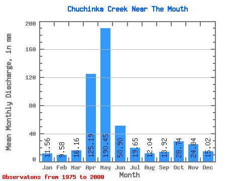
| Statistic | Jan | Feb | Mar | Apr | May | Jun | Jul | Aug | Sep | Oct | Nov | Dec | Annual |
|---|---|---|---|---|---|---|---|---|---|---|---|---|---|
| Mean | 11.56 | 9.66 | 16.15 | 125.19 | 190.42 | 50.90 | 19.65 | 12.04 | 13.92 | 28.73 | 24.84 | 15.02 | 516.64 |
| Standard Deviation | 8.69 | 5.48 | 9.60 | 46.08 | 88.49 | 31.02 | 12.58 | 11.34 | 11.12 | 21.51 | 12.45 | 10.91 | 115.89 |
| Min | 4.16 | 3.65 | 4.39 | 26.42 | 67.51 | 10.25 | 4.18 | 1.96 | 2.72 | 5.53 | 6.41 | 4.46 | 324.51 |
| Max | 43.14 | 22.52 | 37.46 | 237.53 | 390.07 | 112.51 | 55.11 | 43.48 | 41.84 | 95.58 | 48.42 | 61.83 | 790.09 |
| Coefficient of Variation | 0.75 | 0.57 | 0.59 | 0.37 | 0.47 | 0.61 | 0.64 | 0.94 | 0.80 | 0.75 | 0.50 | 0.73 | 0.22 |
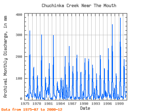
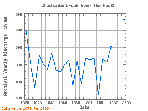
| Year | Jan | Feb | Mar | Apr | May | Jun | Jul | Aug | Sep | Oct | Nov | Dec | Annual | 1975 | 15.76 | 21.44 | 14.42 | 23.25 | 27.75 | 13.86 | 1976 | 9.56 | 8.32 | 8.70 | 93.34 | 328.94 | 99.18 | 32.20 | 35.65 | 30.59 | 23.51 | 15.75 | 14.12 | 695.89 | 1977 | 13.43 | 12.95 | 14.81 | 140.02 | 156.72 | 37.26 | 32.38 | 12.83 | 21.50 | 31.86 | 21.42 | 12.49 | 506.97 | 1978 | 9.21 | 5.57 | 9.13 | 100.01 | 116.25 | 17.92 | 4.18 | 9.82 | 18.17 | 19.98 | 38.26 | 13.09 | 361.32 | 1979 | 6.67 | 5.08 | 17.65 | 63.76 | 310.86 | 105.01 | 19.38 | 4.95 | 5.64 | 10.25 | 6.41 | 4.46 | 556.45 | 1980 | 4.49 | 3.65 | 4.39 | 88.34 | 109.36 | 50.42 | 39.78 | 12.05 | 41.84 | 41.85 | 48.42 | 61.83 | 505.16 | 1981 | 43.14 | 22.52 | 25.57 | 116.68 | 173.94 | 48.67 | 11.62 | 4.62 | 3.34 | 5.59 | 10.34 | 8.34 | 473.87 | 1982 | 4.16 | 3.81 | 4.96 | 26.42 | 307.41 | 96.68 | 35.05 | 25.14 | 18.34 | 20.41 | 17.17 | 10.68 | 565.53 | 1983 | 7.19 | 10.04 | 21.27 | 69.51 | 86.97 | 44.34 | 55.11 | 36.85 | 33.67 | 35.82 | 45.51 | 24.54 | 469.64 | 1984 | 10.59 | 8.79 | 18.94 | 82.26 | 105.05 | 50.17 | 21.18 | 5.00 | 9.92 | 95.58 | 31.50 | 19.20 | 456.50 | 1985 | 8.06 | 5.56 | 6.22 | 105.01 | 208.38 | 34.09 | 6.07 | 2.90 | 19.75 | 71.90 | 25.17 | 7.62 | 498.30 | 1986 | 10.76 | 9.81 | 20.41 | 95.85 | 255.75 | 65.17 | 18.86 | 7.78 | 5.62 | 11.45 | 16.92 | 8.96 | 524.80 | 1987 | 8.70 | 14.44 | 26.69 | 104.18 | 161.02 | 19.75 | 5.66 | 4.78 | 4.12 | 5.53 | 15.59 | 10.25 | 379.94 | 1988 | 6.36 | 4.86 | 7.27 | 176.69 | 213.55 | 53.84 | 14.98 | 7.99 | 5.54 | 10.76 | 13.42 | 9.39 | 523.84 | 1989 | 7.91 | 5.09 | 6.54 | 124.18 | 132.61 | 16.17 | 9.21 | 4.37 | 4.27 | 10.76 | 39.51 | 30.22 | 390.32 | 1990 | 31.00 | 9.02 | 10.68 | 153.35 | 198.05 | 84.18 | 10.59 | 3.13 | 3.26 | 13.43 | 12.09 | 12.31 | 540.50 | 1991 | 12.23 | 18.36 | 17.05 | 165.85 | 195.47 | 44.92 | 10.16 | 4.89 | 7.08 | 18.86 | 16.00 | 18.08 | 528.86 | 1992 | 20.15 | 20.01 | 32.98 | 160.85 | 133.47 | 35.84 | 5.05 | 1.96 | 14.92 | 56.14 | 43.67 | 14.72 | 540.32 | 1993 | 7.68 | 6.63 | 7.87 | 121.68 | 67.51 | 25.17 | 23.42 | 12.49 | 5.94 | 10.16 | 22.59 | 12.83 | 324.51 | 1994 | 11.19 | 8.55 | 21.53 | 205.03 | 174.80 | 24.34 | 16.27 | 3.37 | 4.99 | 28.76 | 22.09 | 12.49 | 533.02 | 1995 | 9.04 | 14.36 | 34.27 | 145.85 | 141.22 | 16.25 | 19.46 | 43.48 | 12.75 | 38.32 | 26.34 | 14.38 | 514.41 | 1996 | 18.17 | 18.99 | 37.46 | 237.53 | 137.78 | 43.67 | 25.06 | 9.73 | 15.50 | 29.11 | 19.67 | 11.45 | 605.41 | 1997 | 7.17 | 7.66 | 16.70 | 150.02 | 359.08 | 97.51 | 24.11 | 8.78 | 6.75 | 57.18 | 46.26 | 12.57 | 790.09 | 1998 | 7.50 | 6.58 | 15.33 | 120.85 | 103.33 | 10.25 | 6.67 | 3.37 | 2.72 | 27.81 | 13.25 | 8.30 | 325.54 | 1999 | 6.12 | 5.30 | 10.94 | 157.52 | 390.07 | 112.51 | 13.52 | 12.23 | 14.84 | 18.60 | 14.67 | 10.51 | 763.34 | 2000 | 8.49 | 5.62 | 6.49 | 125.02 | 192.88 | 39.17 | 35.13 | 13.43 | 36.42 | 30.22 | 36.17 | 13.78 | 541.36 |
|---|
 Return to R-Arctic Net Home Page